Areia Branca night lights from space
Night Light of Areia Branca (Sergipe) from space (Brazil) Src. Average luminocity for 10x10km area is 29.593% and for 50x50km: 33.8498%.
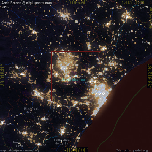
Analysis of Areia Branca night lights 2016
Square area 10x10 km:
 1.24%
1.24%90-99
3.72%80-89
0.83%70-79
3.51%60-69
2.89%50-59
8.06%40-49
1.45%30-39
5.99%20-29
31.4%10-19
30.37%0-9
10.54%Square area 50x50 km:
3.6%90-99
5.72%80-89
3.61%70-79
4.62%60-69
6.41%50-59
6.89%40-49
5.3%30-39
5.86%20-29
9.34%10-19
18.32%0-9
30.33%Clear (daylight) street map image can be seen on geolist.org.
Map coordinates:
10° 3' 58.5" South, 38° 1' 6.3" West
10° 45' 28" South, 37° 18' 55" West
11° 26' 51.9" South, 36° 36' 43.8" West
Some cities around Areia Branca sort by population:
• Nossa Senhora do Socorro
23.3 km =14.5 mi,  117°
117°
• Itabaiana
14.5 km =9 mi,  303°
303°
• Laranjeiras
16.8 km =10.4 mi,  108°
108°
• Maruim
25.6 km =15.9 mi,  84°
84°
• Ribeirópolis
26.7 km =16.6 mi,  335°
335°
• Santo Amaro das Brotas
28.7 km =17.8 mi,  96°
96°
• Campo do Brito
19.6 km =12.2 mi,  277°
277°
• Malhador
11.2 km =7 mi,  5°
5°
3471609 (p: 7,414)
Sources (retrieved 2019-11-25):
» Earth at Night: Flat Maps 2012, 2016