Frei Paulo night lights from space
Night Light of Frei Paulo (Sergipe) from space (Brazil) Src. Average luminocity for 10x10km area is 21.8017% and for 50x50km: 20.6949%.
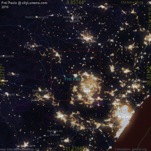
Analysis of Frei Paulo night lights 2016
Square area 10x10 km:
 0.62%
0.62%90-99
3.51%80-89
0.83%70-79
0.83%60-69
3.51%50-59
7.02%40-49
3.1%30-39
2.07%20-29
8.88%10-19
29.34%0-9
40.29%Square area 50x50 km:
1.56%90-99
3.14%80-89
2.42%70-79
3.26%60-69
4.7%50-59
4.66%40-49
3.2%30-39
3.65%20-29
5.42%10-19
7.33%0-9
60.66%Clear (daylight) street map image can be seen on geolist.org.
Map coordinates:
9° 51' 26.8" South, 38° 14' 15.3" West
10° 32' 58" South, 37° 32' 4" West
11° 14' 23.6" South, 36° 49' 52.8" West
Some cities around Frei Paulo sort by population:
• Itabaiana
19.2 km =11.9 mi,  141°
141°
• Simão Dias
36.8 km =22.9 mi,  235°
235°
• Nossa Senhora das Dores
37.8 km =23.5 mi,  80°
80°
• Ribeirópolis
12.9 km =8 mi,  85°
85°
• Carira
27.8 km =17.3 mi,  319°
319°
• Campo do Brito
20.9 km =13 mi,  167°
167°
• Areia Branca
33.3 km =20.7 mi,  134°
134°
• Malhador
27.8 km =17.3 mi,  115°
115°
3462944 (p: 7,047)
Sources (retrieved 2019-11-25):
» Earth at Night: Flat Maps 2012, 2016