Pompéia night lights from space
Night Light of Pompéia (São Paulo) from space (Brazil) Src. Average luminocity for 10x10km area is 17.5556% and for 50x50km: 5.2341%.
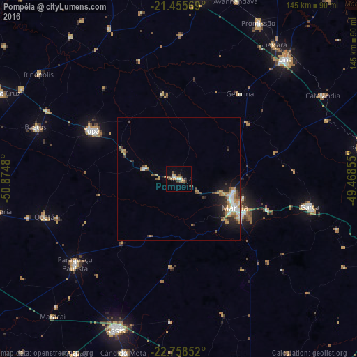
Analysis of Pompéia night lights 2016
Square area 10x10 km:
 1.98%
1.98%90-99
1.98%80-89
0.79%70-79
3.97%60-69
3.37%50-59
1.39%40-49
4.56%30-39
1.79%20-29
0.79%10-19
5.95%0-9
73.41%Square area 50x50 km:
0.71%90-99
0.74%80-89
0.41%70-79
1.14%60-69
0.97%50-59
0.29%40-49
0.97%30-39
0.52%20-29
1.04%10-19
2.44%0-9
90.75%Clear (daylight) street map image can be seen on geolist.org.
Map coordinates:
21° 27' 20.5" South, 50° 52' 29.3" West
22° 6' 31" South, 50° 10' 18" West
22° 45' 30.7" South, 49° 28' 6.8" West
Some cities around Pompéia sort by population:
• Marília
26 km =16.2 mi,  116°
116°
• Assis
66.3 km =41.2 mi,  201°
201°
• Lins
65.2 km =40.5 mi,  42°
42°
• Tupã
40.2 km =25 mi,  298°
298°
• Garça
54.3 km =33.7 mi,  102°
102°
• Paraguaçu Paulista
53.6 km =33.3 mi,  230°
230°
• Bastos
61.6 km =38.3 mi,  289°
289°
• Quatá
56.4 km =35 mi,  254°
254°
3453242 (p: 18,015)
Sources (retrieved 2019-11-25):
» Earth at Night: Flat Maps 2012, 2016