Pirajuí night lights from space
Night Light of Pirajuí (São Paulo) from space (Brazil) Src. Average luminocity for 10x10km area is 19.0774% and for 50x50km: 2.6475%.
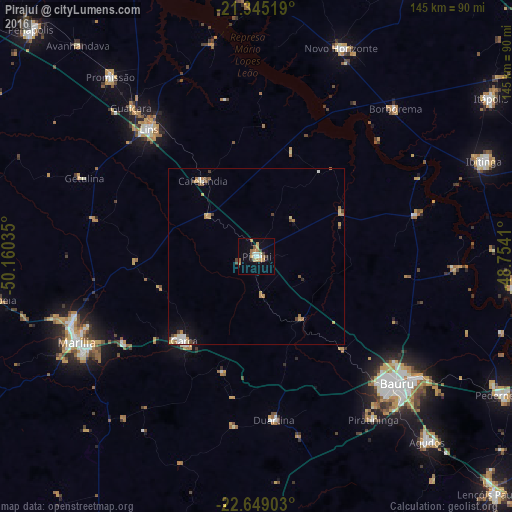
Analysis of Pirajuí night lights 2016
Square area 10x10 km:
 2.78%
2.78%90-99
1.19%80-89
1.79%70-79
5.56%60-69
4.76%50-59
1.19%40-49
1.98%30-39
0.6%20-29
0.79%10-19
5.95%0-9
73.41%Square area 50x50 km:
0.3%90-99
0.31%80-89
0.27%70-79
0.7%60-69
0.49%50-59
0.31%40-49
0.44%30-39
0.11%20-29
0.08%10-19
0.81%0-9
96.18%Clear (daylight) street map image can be seen on geolist.org.
Map coordinates:
21° 20' 42.7" South, 50° 9' 37.3" West
21° 59' 55" South, 49° 27' 26" West
22° 38' 56.5" South, 48° 45' 14.8" West
Some cities around Pirajuí sort by population:
• Bauru
53.9 km =33.5 mi,  130°
130°
• Marília
55.7 km =34.6 mi,  244°
244°
• Lins
46.2 km =28.7 mi,  320°
320°
• Garça
31.2 km =19.4 mi,  221°
221°
• Novo Horizonte
63.8 km =39.6 mi,  22°
22°
• Cafelândia
26.9 km =16.7 mi, 324°
• Duartina
46.6 km =29 mi,  173°
173°
• Borborema
57.8 km =35.9 mi,  43°
43°
3453605 (p: 17,503)
Sources (retrieved 2019-11-25):
» Earth at Night: Flat Maps 2012, 2016