Duartina night lights from space
Night Light of Duartina (São Paulo) from space (Brazil) Src. Average luminocity for 10x10km area is 8.5076% and for 50x50km: 1.4823%.
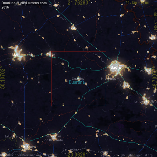
Analysis of Duartina night lights 2016
Square area 10x10 km:
 1.7%
1.7%90-99
1.33%80-89
0%70-79
0.76%60-69
1.89%50-59
1.33%40-49
1.52%30-39
0.95%20-29
0.38%10-19
0%0-9
90.15%Square area 50x50 km:
0.11%90-99
0.08%80-89
0.09%70-79
0.39%60-69
0.3%50-59
0.12%40-49
0.26%30-39
0.29%20-29
0.22%10-19
0.49%0-9
97.65%Clear (daylight) street map image can be seen on geolist.org.
Map coordinates:
21° 45' 46.5" South, 50° 6' 25.3" West
22° 24' 52" South, 49° 24' 14" West
23° 3' 46.5" South, 48° 42' 2.8" West
Some cities around Duartina sort by population:
• Bauru
37 km =23 mi,  72°
72°
• Marília
60 km =37.3 mi,  291°
291°
• Lençóis Paulista
65.3 km =40.6 mi,  108°
108°
• Garça
34.5 km =21.4 mi,  311°
311°
• Pederneiras
65 km =40.4 mi,  83°
83°
• Santa Cruz do Rio Pardo
58.8 km =36.5 mi,  203°
203°
• Agudos
43.2 km =26.8 mi,  98°
98°
• Pirajuí
46.6 km =29 mi,  353°
353°
3464422 (p: 11,902)
Sources (retrieved 2019-11-25):
» Earth at Night: Flat Maps 2012, 2016