Palmital night lights from space
Night Light of Palmital (São Paulo) from space (Brazil) Src. Average luminocity for 10x10km area is 12.3194% and for 50x50km: 4.6102%.
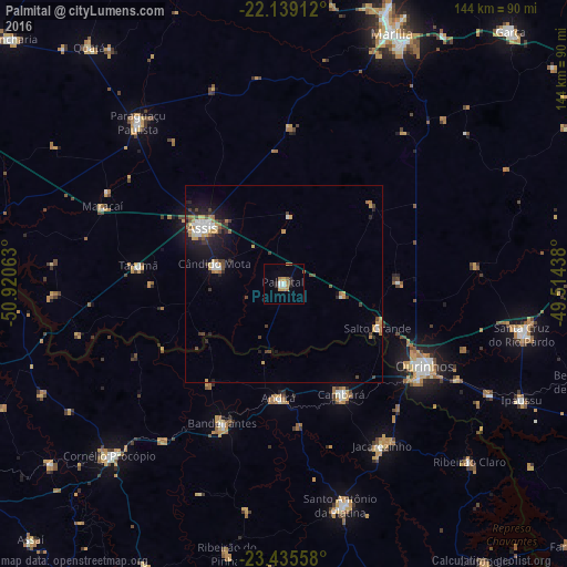
Analysis of Palmital night lights 2016
Square area 10x10 km:
 1.98%
1.98%90-99
1.19%80-89
0.4%70-79
3.57%60-69
2.58%50-59
0.99%40-49
0%30-39
2.18%20-29
1.59%10-19
0.2%0-9
85.32%Square area 50x50 km:
0.64%90-99
0.62%80-89
0.18%70-79
0.97%60-69
0.71%50-59
0.28%40-49
0.64%30-39
0.84%20-29
0.94%10-19
2.98%0-9
91.2%Clear (daylight) street map image can be seen on geolist.org.
Map coordinates:
22° 8' 20.8" South, 50° 55' 14.3" West
22° 47' 20" South, 50° 13' 3" West
23° 26' 8.1" South, 49° 30' 51.8" West
Some cities around Palmital sort by population:
• Assis
24.5 km =15.2 mi,  305°
305°
• Ourinhos
41.3 km =25.7 mi,  120°
120°
• Jacarezinho
48.5 km =30.1 mi,  148°
148°
• Bandeirantes
38.9 km =24.2 mi,  203°
203°
• Cândido Mota
18 km =11.2 mi,  285°
285°
• Cambará
32.2 km =20 mi, 152°
• Maracaí
50.2 km =31.2 mi, 293°
• Tarumã
37.2 km =23.1 mi,  277°
277°
3455342 (p: 18,539)
Sources (retrieved 2019-11-25):
» Earth at Night: Flat Maps 2012, 2016