Maracaí night lights from space
Night Light of Maracaí (São Paulo) from space (Brazil) Src. Average luminocity for 10x10km area is 7.9527% and for 50x50km: 3.5169%.
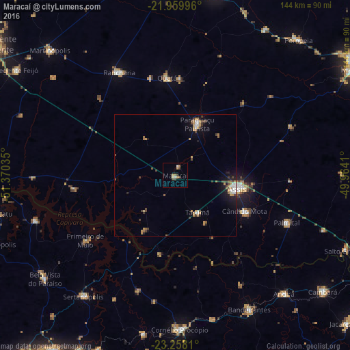
Analysis of Maracaí night lights 2016
Square area 10x10 km:
 0.76%
0.76%90-99
0.76%80-89
1.33%70-79
1.7%60-69
2.08%50-59
0.19%40-49
1.52%30-39
1.52%20-29
0%10-19
0%0-9
90.15%Square area 50x50 km:
0.35%90-99
0.43%80-89
0.3%70-79
0.86%60-69
0.49%50-59
0.22%40-49
0.78%30-39
0.45%20-29
0.37%10-19
2.02%0-9
93.73%Clear (daylight) street map image can be seen on geolist.org.
Map coordinates:
21° 57' 35.9" South, 51° 22' 13.3" West
22° 36' 38" South, 50° 40' 2" West
23° 15' 29.2" South, 49° 57' 50.8" West
Some cities around Maracaí sort by population:
• Assis
26.8 km =16.7 mi,  102°
102°
• Paraguaçu Paulista
23.9 km =14.9 mi,  23°
23°
• Cândido Mota
32.5 km =20.2 mi,  117°
117°
• Rancharia
48.3 km =30 mi,  331°
331°
• Palmital
50.2 km =31.2 mi,  113°
113°
• Sertanópolis
62.6 km =38.9 mi,  217°
217°
• Quatá
40.5 km =25.2 mi,  355°
355°
• Tarumã
17.7 km =11 mi,  148°
148°
3457862 (p: 11,959)
Sources (retrieved 2019-11-25):
» Earth at Night: Flat Maps 2012, 2016