Pacajus night lights from space
Night Light of Pacajus (Ceará) from space (Brazil) Src. Average luminocity for 10x10km area is 53.8052% and for 50x50km: 21.286%.

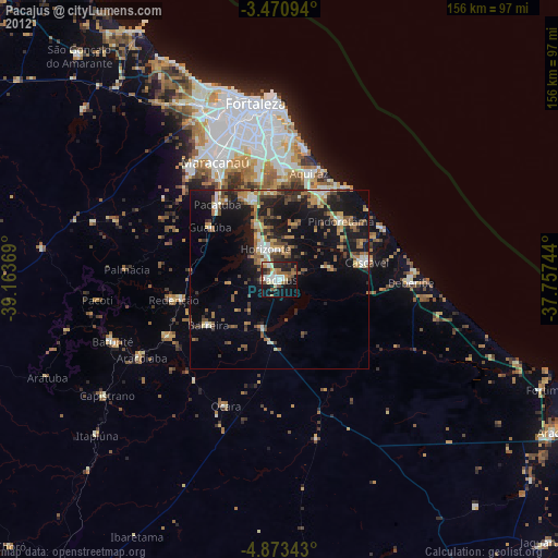
Analysis of Pacajus night lights 2016
Square area 10x10 km:
 8.66%
8.66%90-99
14.29%80-89
3.9%70-79
5.41%60-69
11.69%50-59
7.14%40-49
6.93%30-39
12.55%20-29
9.52%10-19
19.05%0-9
0.87%Square area 50x50 km:
1.04%90-99
3.39%80-89
1.89%70-79
2.19%60-69
3.44%50-59
4.76%40-49
4.37%30-39
5.22%20-29
8.32%10-19
15.26%0-9
50.13%Clear (daylight) street map image can be seen on geolist.org.
Map coordinates:
3° 28' 15.4" South, 39° 9' 49.3" West
4° 10' 21" South, 38° 27' 38" West
4° 52' 24.3" South, 37° 45' 26.8" West
Some cities around Pacajus sort by population:
• Aquiraz
31.1 km =19.3 mi,  14°
14°
• Pacatuba
27.4 km =17 mi,  319°
319°
• Cascavel
24.6 km =15.3 mi,  79°
79°
• Horizonte
8.4 km =5.2 mi,  342°
342°
• Itaitinga
23.8 km =14.8 mi, 341°
• Guaiúba
24.5 km =15.2 mi,  306°
306°
• Redenção
30.5 km =19 mi,  258°
258°
• Chorozinho
14.8 km =9.2 mi,  196°
196°
3393409 (p: 41,558)
Sources (retrieved 2019-11-25):
» Earth at Night: Flat Maps 2012, 2016