Chorozinho night lights from space
Night Light of Chorozinho (Ceará) from space (Brazil) Src. Average luminocity for 10x10km area is 18.974% and for 50x50km: 11.5129%.
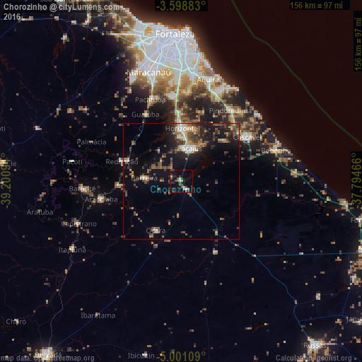
Analysis of Chorozinho night lights 2016
Square area 10x10 km:
 0.43%
0.43%90-99
3.68%80-89
0.87%70-79
0.87%60-69
2.6%50-59
2.38%40-49
6.06%30-39
5.19%20-29
5.19%10-19
9.96%0-9
62.77%Square area 50x50 km:
0.61%90-99
1.66%80-89
0.76%70-79
1.11%60-69
1.81%50-59
2.34%40-49
2.57%30-39
2.85%20-29
3.36%10-19
8.79%0-9
74.14%Clear (daylight) street map image can be seen on geolist.org.
Map coordinates:
3° 35' 55.8" South, 39° 12' 3.3" West
4° 18' 1" South, 38° 29' 52" West
5° 0' 3.9" South, 37° 47' 40.8" West
Some cities around Chorozinho sort by population:
• Cascavel
33.9 km =21.1 mi,  56°
56°
• Horizonte
22.3 km =13.9 mi,  4°
4°
• Pacajus
14.8 km =9.2 mi,  16°
16°
• Itaitinga
36.9 km =22.9 mi,  354°
354°
• Guaiúba
32.8 km =20.4 mi,  331°
331°
• Redenção
27.1 km =16.8 mi,  287°
287°
• Aracoiaba
36 km =22.4 mi,  257°
257°
• Ocara
23.9 km =14.9 mi,  207°
207°
3402164 (p: 9,754)
Sources (retrieved 2019-11-25):
» Earth at Night: Flat Maps 2012, 2016