Mucurici night lights from space
Night Light of Mucurici (Espírito Santo) from space (Brazil) Src. Average luminocity for 10x10km area is 12.3247% and for 50x50km: 1.2186%.
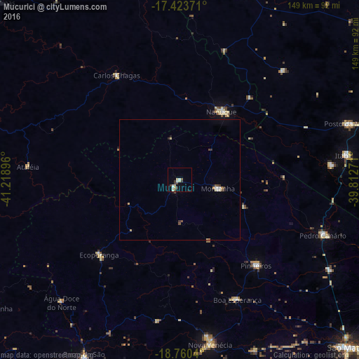
Analysis of Mucurici night lights 2016
Square area 10x10 km:
 2.16%
2.16%90-99
1.3%80-89
4.33%70-79
0%60-69
0%50-59
0.87%40-49
2.38%30-39
3.68%20-29
0.87%10-19
0%0-9
84.42%Square area 50x50 km:
0.14%90-99
0.12%80-89
0.33%70-79
0.08%60-69
0.02%50-59
0.1%40-49
0.27%30-39
0.31%20-29
0.08%10-19
0.06%0-9
98.49%Clear (daylight) street map image can be seen on geolist.org.
Map coordinates:
17° 25' 25.4" South, 41° 13' 8.3" West
18° 5' 36" South, 40° 30' 57" West
18° 45' 37.4" South, 39° 48' 45.8" West
Some cities around Mucurici sort by population:
• Nanuque
33 km =20.5 mi,  31°
31°
• Nova Venécia
69.7 km =43.3 mi,  169°
169°
• Posto da Mata
73.4 km =45.6 mi,  71°
71°
• Barra de São Francisco
83.5 km =51.9 mi,  208°
208°
• Ecoporanga
45.5 km =28.3 mi,  226°
226°
• Carlos Chagas
50.9 km =31.6 mi,  328°
328°
• Montanha
16.5 km =10.3 mi,  103°
103°
• Boa Esperança
54.8 km =34.1 mi,  154°
154°
3456591 (p: 9,524)
Sources (retrieved 2019-11-25):
» Earth at Night: Flat Maps 2012, 2016