Miguel Alves night lights from space
Night Light of Miguel Alves (Piauí) from space (Brazil) Src. Average luminocity for 10x10km area is 8.2662% and for 50x50km: 1.6263%.
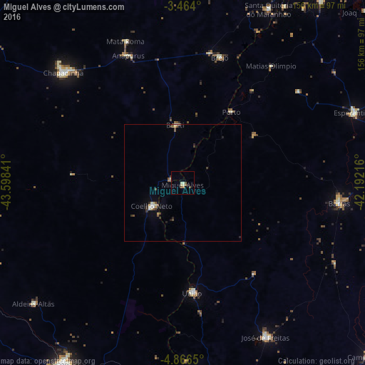
Analysis of Miguel Alves night lights 2016
Square area 10x10 km:
 0%
0%90-99
1.95%80-89
1.95%70-79
0.87%60-69
1.3%50-59
1.73%40-49
0.87%30-39
0.43%20-29
0%10-19
0.87%0-9
90.04%Square area 50x50 km:
0.13%90-99
0.31%80-89
0.23%70-79
0.12%60-69
0.1%50-59
0.38%40-49
0.25%30-39
0.25%20-29
0.29%10-19
0.23%0-9
97.72%Clear (daylight) street map image can be seen on geolist.org.
Map coordinates:
3° 27' 50.4" South, 43° 35' 54.3" West
4° 9' 56" South, 42° 53' 43" West
4° 51' 59.4" South, 42° 11' 31.8" West
Some cities around Miguel Alves sort by population:
• Chapadinha
69.9 km =43.4 mi,  312°
312°
• Coelho Neto
16.5 km =10.3 mi,  232°
232°
• Barras
67.2 km =41.8 mi,  97°
97°
• José de Freitas
74.6 km =46.4 mi,  151°
151°
• Esperantina
79 km =49.1 mi,  68°
68°
• União
46.9 km =29.1 mi,  175°
175°
• Brejo
55.9 km =34.7 mi,  16°
16°
• Porto
36.6 km =22.7 mi,  34°
34°
3394892 (p: 10,438)
Sources (retrieved 2019-11-25):
» Earth at Night: Flat Maps 2012, 2016