Manaquiri night lights from space
Night Light of Manaquiri (Amazonas) from space (Brazil) Src. Average luminocity for 10x10km area is 0.2944% and for 50x50km: 1.1776%.
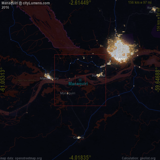
Analysis of Manaquiri night lights 2016
Square area 10x10 km:
 0%
0%90-99
0%80-89
0%70-79
0%60-69
0%50-59
0%40-49
0%30-39
0.87%20-29
0%10-19
0%0-9
99.13%Square area 50x50 km:
0%90-99
0.05%80-89
0.22%70-79
0.15%60-69
0.15%50-59
0.17%40-49
0.28%30-39
0.38%20-29
0.24%10-19
0.18%0-9
98.18%Clear (daylight) street map image can be seen on geolist.org.
Map coordinates:
2° 36' 52.2" South, 61° 3' 11.3" West
3° 19' 0" South, 60° 21' 0" West
4° 1' 6.1" South, 59° 38' 48.8" West
Some cities around Manaquiri sort by population:
• Manaus
43.3 km =26.9 mi,  56°
56°
• Manacapuru
30.1 km =18.7 mi,  273°
273°
• Rio Preto da Eva
99.6 km =61.9 mi,  46°
46°
• Borba
146.3 km =90.9 mi,  144°
144°
• Iranduba
18.5 km =11.5 mi,  78°
78°
• Autazes
138.5 km =86.1 mi,  102°
102°
• Anori
152.3 km =94.6 mi,  250°
250°
• Careiro da Várzea
59.6 km =37 mi, 77°
3663524 (p: 9,981)
Sources (retrieved 2019-11-25):
» Earth at Night: Flat Maps 2012, 2016