Iranduba night lights from space
Night Light of Iranduba (Amazonas) from space (Brazil) Src. Average luminocity for 10x10km area is 14.4459% and for 50x50km: 7.5392%.
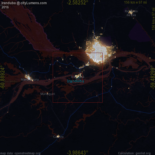
Analysis of Iranduba night lights 2016
Square area 10x10 km:
 0%
0%90-99
1.3%80-89
3.68%70-79
3.68%60-69
2.38%50-59
1.3%40-49
2.81%30-39
1.3%20-29
1.95%10-19
1.73%0-9
79.87%Square area 50x50 km:
2.63%90-99
1.51%80-89
0.67%70-79
0.48%60-69
0.35%50-59
0.55%40-49
1.04%30-39
1.02%20-29
1.68%10-19
2.26%0-9
87.82%Clear (daylight) street map image can be seen on geolist.org.
Map coordinates:
2° 34' 57.1" South, 60° 53' 21.3" West
3° 17' 5" South, 60° 11' 10" West
3° 59' 11.1" South, 59° 28' 58.8" West
Some cities around Iranduba sort by population:
• Manaus
27.1 km =16.8 mi,  41°
41°
• Manacapuru
48.3 km =30 mi,  268°
268°
• Rio Preto da Eva
84.6 km =52.6 mi, 39°
• Nova Olinda do Norte
138.6 km =86.1 mi,  119°
119°
• Borba
139.8 km =86.9 mi,  151°
151°
• Manaquiri
18.5 km =11.5 mi,  258°
258°
• Autazes
121.7 km =75.6 mi,  105°
105°
• Careiro da Várzea
41.1 km =25.5 mi,  76°
76°
3736808 (p: 11,180)
Sources (retrieved 2019-11-25):
» Earth at Night: Flat Maps 2012, 2016