Maruim night lights from space
Night Light of Maruim (Sergipe) from space (Brazil) Src. Average luminocity for 10x10km area is 33.5661% and for 50x50km: 26.6329%.
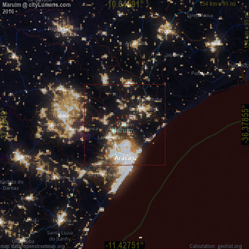
Analysis of Maruim night lights 2016
Square area 10x10 km:
 2.07%
2.07%90-99
4.34%80-89
2.07%70-79
2.69%60-69
3.31%50-59
5.17%40-49
8.26%30-39
11.36%20-29
22.11%10-19
38.64%0-9
0%Square area 50x50 km:
4.67%90-99
4.98%80-89
1.99%70-79
2.07%60-69
3.09%50-59
4.99%40-49
3.8%30-39
4.32%20-29
6.7%10-19
21.08%0-9
42.31%Clear (daylight) street map image can be seen on geolist.org.
Map coordinates:
10° 2' 45.3" South, 37° 47' 5.3" West
10° 44' 15" South, 37° 4' 54" West
11° 25' 39" South, 36° 22' 42.8" West
Some cities around Maruim sort by population:
• Aracaju
19.3 km =12 mi,  176°
176°
• Nossa Senhora do Socorro
13.9 km =8.6 mi,  200°
200°
• Barra dos Coqueiros
19.6 km =12.2 mi,  166°
166°
• Laranjeiras
12.3 km =7.6 mi,  231°
231°
• Santo Amaro das Brotas
6.4 km =4 mi,  152°
152°
• Japaratuba
22.3 km =13.9 mi,  43°
43°
• Areia Branca
25.6 km =15.9 mi,  264°
264°
• Malhador
25.9 km =16.1 mi,  289°
289°
3457582 (p: 12,153)
Sources (retrieved 2019-11-25):
» Earth at Night: Flat Maps 2012, 2016