Itambacuri night lights from space
Night Light of Itambacuri (Minas Gerais) from space (Brazil) Src. Average luminocity for 10x10km area is 8.1017% and for 50x50km: 2.6752%.
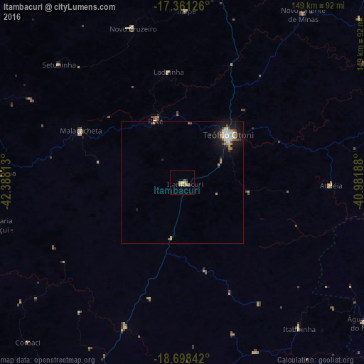
Analysis of Itambacuri night lights 2016
Square area 10x10 km:
 0.87%
0.87%90-99
0.87%80-89
1.73%70-79
1.52%60-69
2.38%50-59
1.08%40-49
0.22%30-39
0.87%20-29
0%10-19
0%0-9
90.48%Square area 50x50 km:
0.3%90-99
0.43%80-89
0.57%70-79
0.24%60-69
0.37%50-59
0.33%40-49
0.34%30-39
0.1%20-29
0.3%10-19
2.53%0-9
94.5%Clear (daylight) street map image can be seen on geolist.org.
Map coordinates:
17° 21' 40.5" South, 42° 23' 17.3" West
18° 1' 52" South, 41° 41' 6" West
18° 41' 54.3" South, 40° 58' 54.8" West
Some cities around Itambacuri sort by population:
• Governador Valadares
95.3 km =59.2 mi,  197°
197°
• Teófilo Otoni
27.1 km =16.8 mi,  44°
44°
• Capelinha
95.7 km =59.5 mi,  293°
293°
• Novo Cruzeiro
65.8 km =40.9 mi,  342°
342°
• Santa Maria do Suaçuí
79.1 km =49.2 mi,  257°
257°
• Divino das Laranjeiras
85.8 km =53.3 mi,  165°
165°
• Malacacheta
46.5 km =28.9 mi,  296°
296°
• Caraí
93.7 km =58.2 mi,  359°
359°
3460817 (p: 14,652)
Sources (retrieved 2019-11-25):
» Earth at Night: Flat Maps 2012, 2016