Itajuípe night lights from space
Night Light of Itajuípe (Bahia) from space (Brazil) Src. Average luminocity for 10x10km area is 4.8781% and for 50x50km: 5.0992%.
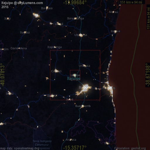
Analysis of Itajuípe night lights 2016
Square area 10x10 km:
 0%
0%90-99
1.24%80-89
1.24%70-79
0%60-69
0%50-59
0.83%40-49
1.45%30-39
1.65%20-29
1.03%10-19
0%0-9
92.56%Square area 50x50 km:
0.64%90-99
1.03%80-89
0.35%70-79
0.45%60-69
0.52%50-59
0.93%40-49
0.78%30-39
0.65%20-29
1.3%10-19
3.46%0-9
89.89%Clear (daylight) street map image can be seen on geolist.org.
Map coordinates:
13° 59' 48.6" South, 40° 4' 41.3" West
14° 40' 41" South, 39° 22' 30" West
15° 21' 25.8" South, 38° 40' 18.8" West
Some cities around Itajuípe sort by population:
• Itabuna
15.7 km =9.8 mi,  139°
139°
• Ilhéus
38.3 km =23.8 mi,  109°
109°
• Coaraci
19.4 km =12.1 mi,  282°
282°
• Ubaitaba
41 km =25.5 mi,  7°
7°
• Uruçuca
13.6 km =8.5 mi,  45°
45°
• Ibicaraí
30.9 km =19.2 mi,  227°
227°
• Buerarema
32.3 km =20.1 mi,  165°
165°
• Ubatã
54.6 km =33.9 mi,  342°
342°
3460831 (p: 15,516)
Sources (retrieved 2019-11-25):
» Earth at Night: Flat Maps 2012, 2016