Irauçuba night lights from space
Night Light of Irauçuba (Ceará) from space (Brazil) Src. Average luminocity for 10x10km area is 6.9177% and for 50x50km: 2.3088%.
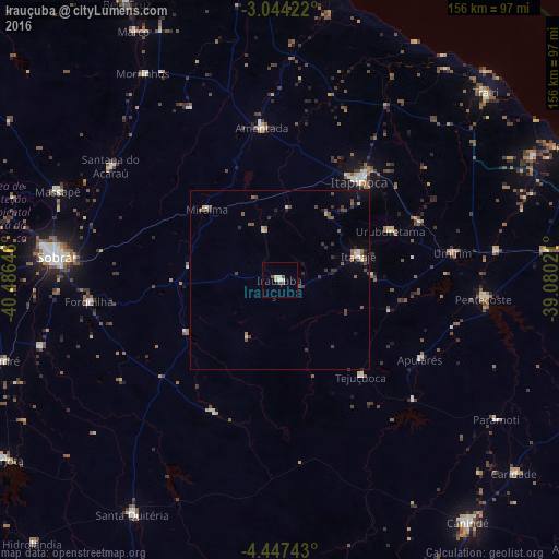
Analysis of Irauçuba night lights 2016
Square area 10x10 km:
 0.43%
0.43%90-99
2.38%80-89
0.87%70-79
0.65%60-69
0%50-59
0.87%40-49
1.95%30-39
0.65%20-29
0%10-19
0.87%0-9
91.34%Square area 50x50 km:
0.08%90-99
0.32%80-89
0.16%70-79
0.23%60-69
0.12%50-59
0.66%40-49
0.73%30-39
0.51%20-29
0.44%10-19
0.63%0-9
96.11%Clear (daylight) street map image can be seen on geolist.org.
Map coordinates:
3° 2' 39.2" South, 40° 29' 11.3" West
3° 44' 46" South, 39° 46' 60" West
4° 26' 50.7" South, 39° 4' 48.8" West
Some cities around Irauçuba sort by population:
• Itapipoca
36 km =22.4 mi,  39°
39°
• Itapagé
22.9 km =14.2 mi,  73°
73°
• Pentecoste
57.2 km =35.5 mi,  95°
95°
• Santana do Acaraú
57.2 km =35.5 mi,  303°
303°
• Amontada
43.1 km =26.8 mi,  352°
352°
• Forquilha
53.3 km =33.1 mi,  263°
263°
• Umirim
48.7 km =30.3 mi,  80°
80°
• Uruburetama
33.4 km =20.8 mi, 66°
3398028 (p: 13,281)
Sources (retrieved 2019-11-25):
» Earth at Night: Flat Maps 2012, 2016