Pentecoste night lights from space
Night Light of Pentecoste (Ceará) from space (Brazil) Src. Average luminocity for 10x10km area is 14.4416% and for 50x50km: 2.7779%.
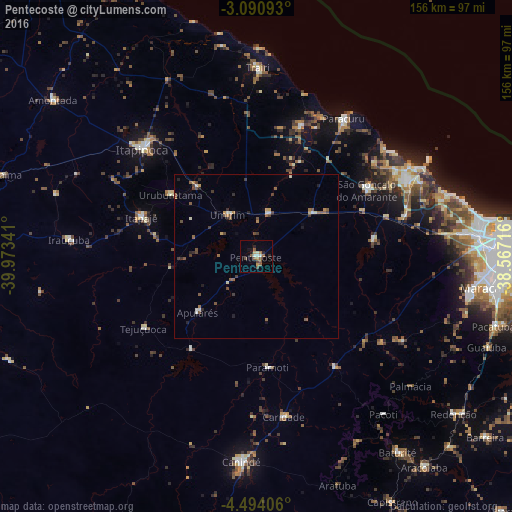
Analysis of Pentecoste night lights 2016
Square area 10x10 km:
 1.3%
1.3%90-99
2.16%80-89
0.65%70-79
1.08%60-69
2.16%50-59
5.63%40-49
2.6%30-39
0%20-29
2.6%10-19
2.6%0-9
79.22%Square area 50x50 km:
0.12%90-99
0.41%80-89
0.12%70-79
0.32%60-69
0.37%50-59
0.88%40-49
0.62%30-39
0.35%20-29
0.57%10-19
0.26%0-9
95.97%Clear (daylight) street map image can be seen on geolist.org.
Map coordinates:
3° 5' 27.3" South, 39° 58' 24.3" West
3° 47' 34" South, 39° 16' 13" West
4° 29' 38.6" South, 38° 34' 1.8" West
Some cities around Pentecoste sort by population:
• Itapipoca
47.7 km =29.6 mi,  314°
314°
• Itapagé
37 km =23 mi,  288°
288°
• São Gonçalo do Amarante
39.3 km =24.4 mi,  58°
58°
• Paracuru
50.2 km =31.2 mi,  32°
32°
• Paraipaba
41.6 km =25.8 mi,  19°
19°
• Umirim
15.6 km =9.7 mi,  325°
325°
• Uruburetama
32.3 km =20.1 mi, 305°
• Jardim
43.5 km =27 mi, 32°
3392345 (p: 19,680)
Sources (retrieved 2019-11-25):
» Earth at Night: Flat Maps 2012, 2016