Ilhabela night lights from space
Night Light of Ilhabela (São Paulo) from space (Brazil) Src. Average luminocity for 10x10km area is 24.3254% and for 50x50km: 6.6832%.

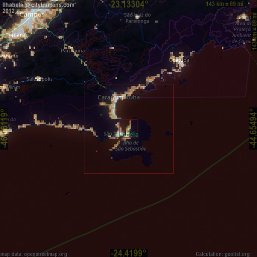
Analysis of Ilhabela night lights 2016
Square area 10x10 km:
 1.98%
1.98%90-99
2.78%80-89
3.37%70-79
5.16%60-69
2.18%50-59
4.76%40-49
2.78%30-39
2.78%20-29
4.37%10-19
30.16%0-9
39.68%Square area 50x50 km:
0.57%90-99
0.67%80-89
0.7%70-79
0.91%60-69
1.24%50-59
1.22%40-49
0.82%30-39
0.66%20-29
1.47%10-19
7.52%0-9
84.22%Clear (daylight) street map image can be seen on geolist.org.
Map coordinates:
23° 7' 58.9" South, 46° 3' 40.3" West
23° 46' 41" South, 45° 21' 29" West
24° 25' 11.6" South, 44° 39' 17.8" West
Some cities around Ilhabela sort by population:
• Jacareí
81.3 km =50.5 mi,  310°
310°
• Caraguatatuba
18.4 km =11.4 mi,  342°
342°
• Ubatuba
48.2 km =30 mi,  37°
37°
• São Sebastião
5.6 km =3.5 mi,  290°
290°
• Bertioga
79.9 km =49.6 mi,  263°
263°
• Biritiba Mirim
73 km =45.4 mi, 288°
• Guararema
79.9 km =49.6 mi,  300°
300°
• Santa Branca
68.3 km =42.4 mi, 308°
3461425 (p: 32,892)
Sources (retrieved 2019-11-25):
» Earth at Night: Flat Maps 2012, 2016