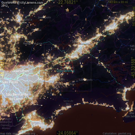
Guararema night lights from space
Night Light of Guararema (São Paulo) from space (Brazil) Src. Average luminocity for 10x10km area is 40.3769% and for 50x50km: 29.7821%.
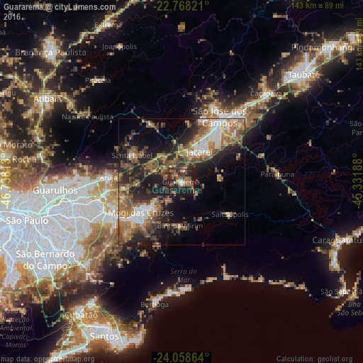
Analysis of Guararema night lights 2016
Square area 10x10 km:
 1.89%
1.89%90-99
4.36%80-89
2.65%70-79
3.98%60-69
8.52%50-59
14.02%40-49
7.77%30-39
13.64%20-29
17.8%10-19
24.81%0-9
0.57%Square area 50x50 km:
3.44%90-99
3.81%80-89
2.83%70-79
4.05%60-69
6.23%50-59
6.75%40-49
5.94%30-39
5.89%20-29
8.81%10-19
13.41%0-9
38.85%Clear (daylight) street map image can be seen on geolist.org.
Map coordinates:
22° 46' 5.6" South, 46° 44' 17.3" West
23° 24' 54" South, 46° 2' 6" West
24° 3' 31.1" South, 45° 19' 54.8" West
Some cities around Guararema sort by population:
• São José dos Campos
30.2 km =18.8 mi,  29°
29°
• Mogi das Cruzes
19.7 km =12.2 mi,  232°
232°
• Suzano
31.5 km =19.6 mi,  243°
243°
• Jacareí
14.1 km =8.8 mi, 30°
• Arujá
29.2 km =18.1 mi,  274°
274°
• Santa Isabel
22 km =13.7 mi,  300°
300°
• Biritiba Mirim
17.5 km =10.9 mi,  181°
181°
• Santa Branca
15.6 km =9.7 mi,  82°
82°
3461871 (p: 23,572)
Sources (retrieved 2019-11-25):
» Earth at Night: Flat Maps 2012, 2016