Abadiânia night lights from space
Night Light of Abadiânia (Goiás) from space (Brazil) Src. Average luminocity for 10x10km area is 6.5971% and for 50x50km: 4.8752%.
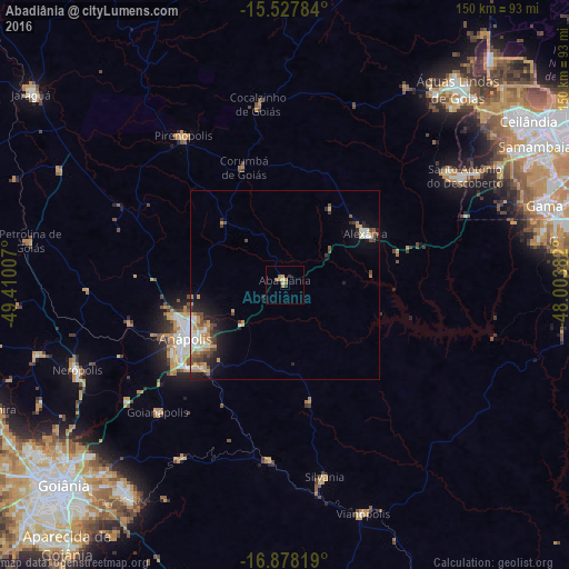
Analysis of Abadiânia night lights 2016
Square area 10x10 km:
 0%
0%90-99
0%80-89
1.65%70-79
1.86%60-69
1.65%50-59
2.27%40-49
0%30-39
0.83%20-29
0.83%10-19
0%0-9
90.91%Square area 50x50 km:
0.51%90-99
0.77%80-89
0.5%70-79
1.05%60-69
0.65%50-59
0.59%40-49
0.94%30-39
0.53%20-29
1.19%10-19
2.42%0-9
90.85%Clear (daylight) street map image can be seen on geolist.org.
Map coordinates:
15° 31' 40.2" South, 49° 24' 36.3" West
16° 12' 15" South, 48° 42' 25" West
16° 52' 41.5" South, 48° 0' 13.8" West
Some cities around Abadiânia sort by population:
• Anápolis
29.6 km =18.4 mi,  242°
242°
• Senador Canedo
69.5 km =43.2 mi,  216°
216°
• Nerópolis
59.1 km =36.7 mi,  247°
247°
• Pirenópolis
47.8 km =29.7 mi,  325°
325°
• Silvânia
51.6 km =32.1 mi,  168°
168°
• Goianápolis
48 km =29.8 mi, 224°
• Vianópolis
63.2 km =39.3 mi,  161°
161°
• Petrolina de Goiás
68.5 km =42.6 mi,  280°
280°
3473268 (p: 7,062)
Sources (retrieved 2019-11-25):
» Earth at Night: Flat Maps 2012, 2016