Altinho night lights from space
Night Light of Altinho (Pernambuco) from space (Brazil) Src. Average luminocity for 10x10km area is 4.3017% and for 50x50km: 5.7574%.
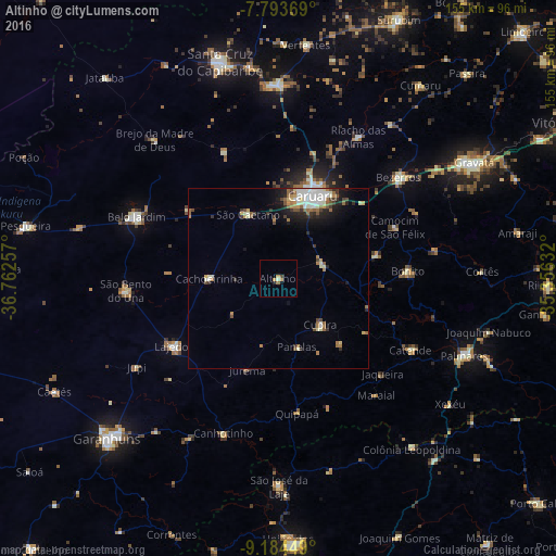
Analysis of Altinho night lights 2016
Square area 10x10 km:
 0%
0%90-99
0.62%80-89
0.21%70-79
1.65%60-69
1.45%50-59
0.21%40-49
0.83%30-39
0%20-29
0.83%10-19
0.41%0-9
93.8%Square area 50x50 km:
0.87%90-99
1.37%80-89
0.36%70-79
0.46%60-69
1.13%50-59
0.77%40-49
0.67%30-39
0.77%20-29
1.02%10-19
2.43%0-9
90.15%Clear (daylight) street map image can be seen on geolist.org.
Map coordinates:
7° 47' 37.3" South, 36° 45' 45.3" West
8° 29' 23" South, 36° 3' 34" West
9° 11' 4.2" South, 35° 21' 22.8" West
Some cities around Altinho sort by population:
• Caruaru
24.7 km =15.3 mi,  21°
21°
• Lajedo
34.6 km =21.5 mi,  235°
235°
• Cupira
18.5 km =11.5 mi,  139°
139°
• Agrestina
13.1 km =8.1 mi,  74°
74°
• São Joaquim do Monte
28.8 km =17.9 mi,  77°
77°
• Cachoeirinha
19.1 km =11.9 mi,  271°
271°
• Camocim de São Félix
35.8 km =22.2 mi, 65°
• Bonito
36.4 km =22.6 mi,  86°
86°
3407871 (p: 11,913)
Sources (retrieved 2019-11-25):
» Earth at Night: Flat Maps 2012, 2016