Charqueada night lights from space
Night Light of Charqueada (São Paulo) from space (Brazil) Src. Average luminocity for 10x10km area is 15.8731% and for 50x50km: 15.7403%.
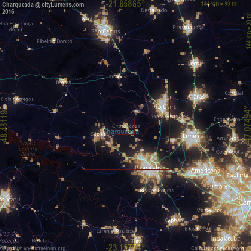
Analysis of Charqueada night lights 2016
Square area 10x10 km:
 0.38%
0.38%90-99
0.38%80-89
3.03%70-79
3.79%60-69
4.36%50-59
3.22%40-49
0.76%30-39
1.33%20-29
0.19%10-19
4.55%0-9
78.03%Square area 50x50 km:
1.97%90-99
1.79%80-89
1.57%70-79
3.26%60-69
2.77%50-59
2.48%40-49
1.6%30-39
2.13%20-29
3.66%10-19
10.61%0-9
68.15%Clear (daylight) street map image can be seen on geolist.org.
Map coordinates:
21° 51' 31.1" South, 48° 28' 52.3" West
22° 30' 35" South, 47° 46' 41" West
23° 9' 27.9" South, 47° 4' 29.8" West
Some cities around Charqueada sort by population:
• Piracicaba
27.4 km =17 mi,  151°
151°
• Limeira
39.1 km =24.3 mi,  98°
98°
• Rio Claro
24.8 km =15.4 mi,  63°
63°
• São Pedro
14.6 km =9.1 mi,  252°
252°
• Cordeirópolis
33.2 km =20.6 mi,  84°
84°
• Santa Gertrudes
26.1 km =16.2 mi, 76°
• Iracemápolis
27.8 km =17.3 mi,  106°
106°
• Itirapina
28.9 km =18 mi,  350°
350°
3466267 (p: 12,391)
Sources (retrieved 2019-11-25):
» Earth at Night: Flat Maps 2012, 2016