Iracemápolis night lights from space
Night Light of Iracemápolis (São Paulo) from space (Brazil) Src. Average luminocity for 10x10km area is 28.3655% and for 50x50km: 34.7903%.
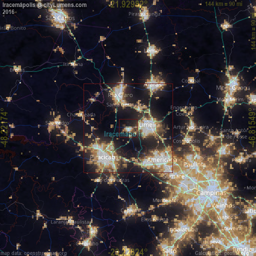
Analysis of Iracemápolis night lights 2016
Square area 10x10 km:
 2.46%
2.46%90-99
2.08%80-89
0.19%70-79
8.14%60-69
2.65%50-59
3.41%40-49
5.68%30-39
9.09%20-29
12.12%10-19
27.08%0-9
27.08%Square area 50x50 km:
5.84%90-99
6.14%80-89
3.68%70-79
6.02%60-69
4.83%50-59
4.1%40-49
4.43%30-39
5.77%20-29
9.67%10-19
18.5%0-9
31.03%Clear (daylight) street map image can be seen on geolist.org.
Map coordinates:
21° 55' 47.4" South, 48° 13' 18.3" West
22° 34' 50" South, 47° 31' 7" West
23° 13' 41.7" South, 46° 48' 55.8" West
Some cities around Iracemápolis sort by population:
• Piracicaba
20.9 km =13 mi,  219°
219°
• Limeira
12.1 km =7.5 mi,  81°
81°
• Americana
26.1 km =16.2 mi,  132°
132°
• Santa Bárbara d'Oeste
22.1 km =13.7 mi,  150°
150°
• Rio Claro
19.3 km =12 mi,  346°
346°
• Cordeirópolis
12.7 km =7.9 mi,  30°
30°
• Santa Gertrudes
13.8 km =8.6 mi,  355°
355°
• Charqueada
27.8 km =17.3 mi,  286°
286°
3461055 (p: 16,795)
Sources (retrieved 2019-11-25):
» Earth at Night: Flat Maps 2012, 2016