Santa Gertrudes night lights from space
Night Light of Santa Gertrudes (São Paulo) from space (Brazil) Src. Average luminocity for 10x10km area is 41.9602% and for 50x50km: 22.4053%.
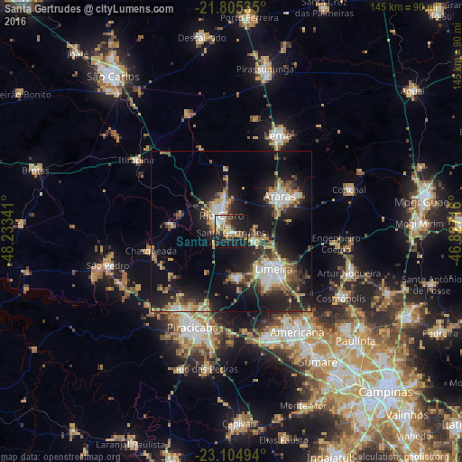
Analysis of Santa Gertrudes night lights 2016
Square area 10x10 km:
 6.63%
6.63%90-99
7.2%80-89
3.41%70-79
6.06%60-69
5.68%50-59
7.39%40-49
5.49%30-39
5.3%20-29
15.53%10-19
35.61%0-9
1.7%Square area 50x50 km:
2.93%90-99
2.96%80-89
2.04%70-79
3.94%60-69
2.83%50-59
2.93%40-49
2.95%30-39
4.13%20-29
7.66%10-19
17.86%0-9
49.78%Clear (daylight) street map image can be seen on geolist.org.
Map coordinates:
21° 48' 19.3" South, 48° 14' 0.3" West
22° 27' 24" South, 47° 31' 49" West
23° 6' 17.8" South, 46° 49' 37.8" West
Some cities around Santa Gertrudes sort by population:
• Piracicaba
32.3 km =20.1 mi,  202°
202°
• Limeira
17.9 km =11.1 mi,  132°
132°
• Rio Claro
6 km =3.7 mi,  327°
327°
• Araras
18.7 km =11.6 mi,  53°
53°
• Leme
33.4 km =20.8 mi,  25°
25°
• Cordeirópolis
8.1 km =5 mi,  110°
110°
• Iracemápolis
13.8 km =8.6 mi,  175°
175°
• Charqueada
26.1 km =16.2 mi,  256°
256°
3450225 (p: 18,490)
Sources (retrieved 2019-11-25):
» Earth at Night: Flat Maps 2012, 2016