Itirapina night lights from space
Night Light of Itirapina (São Paulo) from space (Brazil) Src. Average luminocity for 10x10km area is 12.1705% and for 50x50km: 5.7128%.
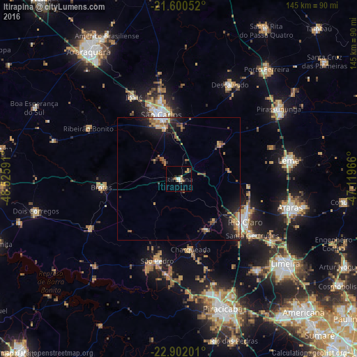
Analysis of Itirapina night lights 2016
Square area 10x10 km:
 0.95%
0.95%90-99
1.33%80-89
0.76%70-79
3.41%60-69
2.27%50-59
0.38%40-49
0.38%30-39
2.27%20-29
4.17%10-19
1.89%0-9
82.2%Square area 50x50 km:
0.45%90-99
0.44%80-89
0.49%70-79
1.25%60-69
0.93%50-59
0.91%40-49
0.87%30-39
0.9%20-29
1.79%10-19
3.5%0-9
88.46%Clear (daylight) street map image can be seen on geolist.org.
Map coordinates:
21° 36' 1.9" South, 48° 31' 33.3" West
22° 15' 10" South, 47° 49' 22" West
22° 54' 7.2" South, 47° 7' 10.8" West
Some cities around Itirapina sort by population:
• São Carlos
27.1 km =16.8 mi,  345°
345°
• Rio Claro
32.2 km =20 mi,  123°
123°
• Ibaté
37.7 km =23.4 mi,  331°
331°
• São Pedro
34.2 km =21.3 mi,  195°
195°
• Brotas
31.5 km =19.6 mi,  263°
263°
• Santa Gertrudes
37.7 km =23.4 mi,  127°
127°
• Charqueada
28.9 km =18 mi,  170°
170°
• Ribeirão Bonito
41.9 km =26 mi,  299°
299°
3460553 (p: 13,229)
Sources (retrieved 2019-11-25):
» Earth at Night: Flat Maps 2012, 2016