Capela do Alto night lights from space
Night Light of Capela do Alto (São Paulo) from space (Brazil) Src. Average luminocity for 10x10km area is 13.3617% and for 50x50km: 19.354%.
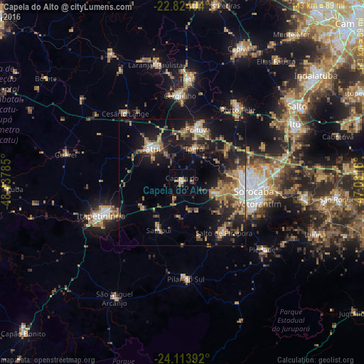
Analysis of Capela do Alto night lights 2016
Square area 10x10 km:
 0.57%
0.57%90-99
0.95%80-89
1.89%70-79
4.17%60-69
0.76%50-59
0.95%40-49
0.76%30-39
4.17%20-29
0.95%10-19
1.7%0-9
83.14%Square area 50x50 km:
1.51%90-99
1.42%80-89
1.77%70-79
4.42%60-69
3.26%50-59
3.31%40-49
2.67%30-39
4.29%20-29
5.34%10-19
15.36%0-9
56.67%Clear (daylight) street map image can be seen on geolist.org.
Map coordinates:
22° 49' 26.5" South, 48° 26' 16.3" West
23° 28' 14" South, 47° 44' 5" West
24° 6' 50.1" South, 47° 1' 53.8" West
Some cities around Capela do Alto sort by population:
• Sorocaba
28.4 km =17.6 mi,  96°
96°
• Votorantim
31.4 km =19.5 mi,  105°
105°
• Tatuí
17.9 km =11.1 mi,  315°
315°
• Boituva
21.8 km =13.5 mi,  17°
17°
• Cerquilho
34 km =21.1 mi,  358°
358°
• Salto de Pirapora
25.8 km =16 mi,  140°
140°
• Iperó
14.2 km =8.8 mi, 19°
• Araçoiaba da Serra
12.9 km =8 mi, 107°
3467314 (p: 11,991)
Sources (retrieved 2019-11-25):
» Earth at Night: Flat Maps 2012, 2016