Iperó night lights from space
Night Light of Iperó (São Paulo) from space (Brazil) Src. Average luminocity for 10x10km area is 30.303% and for 50x50km: 23.4914%.
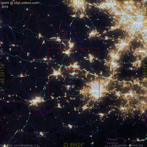
Analysis of Iperó night lights 2016
Square area 10x10 km:
 0.57%
0.57%90-99
0.95%80-89
2.08%70-79
5.3%60-69
4.55%50-59
10.61%40-49
7.01%30-39
6.82%20-29
18.37%10-19
22.16%0-9
21.59%Square area 50x50 km:
3.87%90-99
2.49%80-89
2%70-79
4.6%60-69
3.54%50-59
3.48%40-49
2.5%30-39
4.4%20-29
5.27%10-19
16.63%0-9
51.22%Clear (daylight) street map image can be seen on geolist.org.
Map coordinates:
22° 42' 11.4" South, 48° 23' 30.3" West
23° 21' 1" South, 47° 41' 19" West
23° 59' 39.3" South, 46° 59' 7.8" West
Some cities around Iperó sort by population:
• Sorocaba
28.9 km =18 mi,  125°
125°
• Tatuí
17.2 km =10.7 mi,  268°
268°
• Boituva
7.6 km =4.7 mi,  12°
12°
• Porto Feliz
22.6 km =14 mi,  48°
48°
• Cerquilho
21.4 km =13.3 mi,  344°
344°
• Tietê
27.7 km =17.2 mi,  354°
354°
• Araçoiaba da Serra
18.8 km =11.7 mi,  156°
156°
• Capela do Alto
14.2 km =8.8 mi,  199°
199°
3461134 (p: 17,160)
Sources (retrieved 2019-11-25):
» Earth at Night: Flat Maps 2012, 2016