Camanducaia night lights from space
Night Light of Camanducaia (Minas Gerais) from space (Brazil) Src. Average luminocity for 10x10km area is 12.9841% and for 50x50km: 5.1078%.
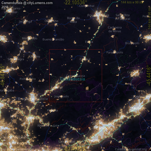
Analysis of Camanducaia night lights 2016
Square area 10x10 km:
 0.6%
0.6%90-99
0.79%80-89
3.17%70-79
3.37%60-69
0.79%50-59
1.59%40-49
1.59%30-39
0.79%20-29
4.17%10-19
0.2%0-9
82.94%Square area 50x50 km:
0.21%90-99
0.29%80-89
0.53%70-79
1.09%60-69
0.96%50-59
0.82%40-49
0.88%30-39
0.92%20-29
1.01%10-19
3.37%0-9
89.93%Clear (daylight) street map image can be seen on geolist.org.
Map coordinates:
22° 6' 19.3" South, 46° 50' 52.3" West
22° 45' 19" South, 46° 8' 41" West
23° 24' 7.7" South, 45° 26' 29.8" West
Some cities around Camanducaia sort by population:
• Bragança Paulista
46.4 km =28.8 mi,  241°
241°
• Piracaia
39.7 km =24.7 mi,  213°
213°
• Socorro
43.4 km =27 mi,  294°
294°
• Cambuí
18.3 km =11.4 mi,  29°
29°
• Extrema
20.9 km =13 mi, 238°
• Paraisópolis
43.6 km =27.1 mi,  59°
59°
• Joanópolis
23.6 km =14.7 mi, 214°
• Bueno Brandão
40.9 km =25.4 mi,  328°
328°
3468023 (p: 17,822)
Sources (retrieved 2019-11-25):
» Earth at Night: Flat Maps 2012, 2016