Extrema night lights from space
Night Light of Extrema (Minas Gerais) from space (Brazil) Src. Average luminocity for 10x10km area is 35.3532% and for 50x50km: 9.683%.
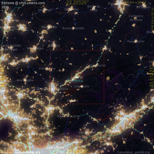
Analysis of Extrema night lights 2016
Square area 10x10 km:
 2.38%
2.38%90-99
3.97%80-89
4.37%70-79
8.93%60-69
6.55%50-59
6.15%40-49
3.97%30-39
5.95%20-29
3.37%10-19
43.06%0-9
11.31%Square area 50x50 km:
0.62%90-99
0.9%80-89
1.09%70-79
1.59%60-69
1.49%50-59
1.63%40-49
1.5%30-39
1.88%20-29
2.72%10-19
6.84%0-9
79.75%Clear (daylight) street map image can be seen on geolist.org.
Map coordinates:
22° 12' 18.9" South, 47° 1' 17.3" West
22° 51' 17" South, 46° 19' 6" West
23° 30' 3.9" South, 45° 36' 54.8" West
Some cities around Extrema sort by population:
• Bragança Paulista
25.6 km =15.9 mi,  244°
244°
• Atibaia
37.6 km =23.4 mi,  219°
219°
• Piracaia
22.5 km =14 mi,  190°
190°
• Socorro
36.4 km =22.6 mi,  323°
323°
• Cambuí
38 km =23.6 mi,  44°
44°
• Camanducaia
20.9 km =13 mi,  58°
58°
• Bom Jesus dos Perdões
34.6 km =21.5 mi,  205°
205°
• Joanópolis
9.5 km =5.9 mi,  152°
152°
3463668 (p: 13,682)
Sources (retrieved 2019-11-25):
» Earth at Night: Flat Maps 2012, 2016