Bueno Brandão night lights from space
Night Light of Bueno Brandão (Minas Gerais) from space (Brazil) Src. Average luminocity for 10x10km area is 4.0833% and for 50x50km: 4.0733%.
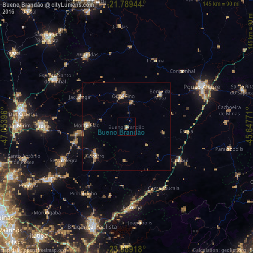
Analysis of Bueno Brandão night lights 2016
Square area 10x10 km:
 0.38%
0.38%90-99
0.38%80-89
0%70-79
1.33%60-69
0.95%50-59
0%40-49
0.76%30-39
0.95%20-29
1.89%10-19
0.19%0-9
93.18%Square area 50x50 km:
0.23%90-99
0.31%80-89
0.62%70-79
0.75%60-69
0.71%50-59
0.6%40-49
0.51%30-39
0.6%20-29
0.53%10-19
1.67%0-9
93.46%Clear (daylight) street map image can be seen on geolist.org.
Map coordinates:
21° 47' 22" South, 47° 3' 14.3" West
22° 26' 27" South, 46° 21' 3" West
23° 5' 21" South, 45° 38' 51.8" West
Some cities around Bueno Brandão sort by population:
• Socorro
24.8 km =15.4 mi,  227°
227°
• Serra Negra
40.7 km =25.3 mi,  242°
242°
• Cambuí
35.6 km =22.1 mi,  122°
122°
• Águas de Lindóia
29.2 km =18.1 mi,  262°
262°
• Jacutinga
31.9 km =19.8 mi,  302°
302°
• Camanducaia
40.9 km =25.4 mi,  148°
148°
• Borda da Mata
26.6 km =16.5 mi,  45°
45°
• Monte Sião
22.8 km =14.2 mi,  272°
272°
3468869 (p: 5,777)
Sources (retrieved 2019-11-25):
» Earth at Night: Flat Maps 2012, 2016