Paraisópolis night lights from space
Night Light of Paraisópolis (Minas Gerais) from space (Brazil) Src. Average luminocity for 10x10km area is 5.6023% and for 50x50km: 3.8777%.
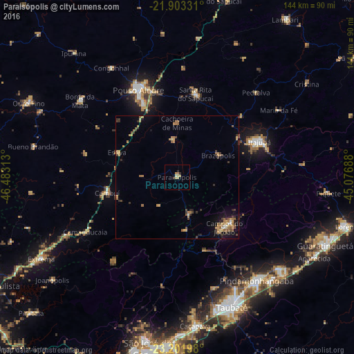
Analysis of Paraisópolis night lights 2016
Square area 10x10 km:
 0%
0%90-99
0.76%80-89
1.33%70-79
2.08%60-69
1.14%50-59
0%40-49
0%30-39
1.33%20-29
0.95%10-19
0%0-9
92.42%Square area 50x50 km:
0.06%90-99
0.23%80-89
0.71%70-79
0.86%60-69
0.76%50-59
0.71%40-49
0.49%30-39
0.82%20-29
0.53%10-19
1.76%0-9
93.08%Clear (daylight) street map image can be seen on geolist.org.
Map coordinates:
21° 54' 11.9" South, 46° 28' 59.3" West
22° 33' 15" South, 45° 46' 48" West
23° 12' 7.1" South, 45° 4' 36.8" West
Some cities around Paraisópolis sort by population:
• Pouso Alegre
39.5 km =24.5 mi,  335°
335°
• Itajubá
36.5 km =22.7 mi,  66°
66°
• Campos do Jordão
28.3 km =17.6 mi,  136°
136°
• Tremembé
50.8 km =31.6 mi,  152°
152°
• Santa Rita do Sapucaí
34.5 km =21.4 mi,  13°
13°
• Cambuí
29.2 km =18.1 mi,  257°
257°
• Camanducaia
43.6 km =27.1 mi,  239°
239°
• Borda da Mata
50.4 km =31.3 mi,  308°
308°
3455089 (p: 13,563)
Sources (retrieved 2019-11-25):
» Earth at Night: Flat Maps 2012, 2016