Buriti dos Lopes night lights from space
Night Light of Buriti dos Lopes (Piauí) from space (Brazil) Src. Average luminocity for 10x10km area is 3.9199% and for 50x50km: 1.5569%.
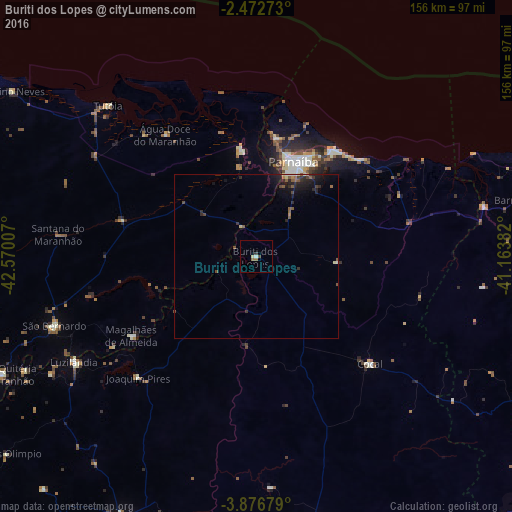
Analysis of Buriti dos Lopes night lights 2016
Square area 10x10 km:
 0%
0%90-99
1.3%80-89
0.43%70-79
0%60-69
1.52%50-59
0.22%40-49
0.87%30-39
0.87%20-29
0%10-19
0%0-9
94.81%Square area 50x50 km:
0%90-99
0.14%80-89
0.17%70-79
0.01%60-69
0.23%50-59
0.55%40-49
0.29%30-39
0.32%20-29
0.72%10-19
1.47%0-9
96.11%Clear (daylight) street map image can be seen on geolist.org.
Map coordinates:
2° 28' 21.8" South, 42° 34' 12.3" West
3° 10' 30" South, 41° 52' 1" West
3° 52' 36.4" South, 41° 9' 49.8" West
Some cities around Buriti dos Lopes sort by population:
• Parnaíba
31.7 km =19.7 mi,  18°
18°
• Luzilândia
64.1 km =39.8 mi,  240°
240°
• Tutóia
64.5 km =40.1 mi,  315°
315°
• Cocal
47.6 km =29.6 mi,  133°
133°
• Luís Correia
39.7 km =24.7 mi,  34°
34°
• São Bernardo
64.6 km =40.1 mi,  251°
251°
• Araioses
31.9 km =19.8 mi,  352°
352°
• Juá dos Vieiras
74.5 km =46.3 mi,  122°
122°
3404713 (p: 9,475)
Sources (retrieved 2019-11-25):
» Earth at Night: Flat Maps 2012, 2016