Beberibe night lights from space
Night Light of Beberibe (Ceará) from space (Brazil) Src. Average luminocity for 10x10km area is 36.4654% and for 50x50km: 10.9555%.
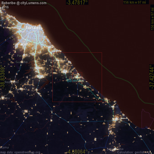

Analysis of Beberibe night lights 2016
Square area 10x10 km:
 1.52%
1.52%90-99
4.55%80-89
3.68%70-79
5.84%60-69
8.23%50-59
10.82%40-49
4.11%30-39
5.84%20-29
7.14%10-19
41.99%0-9
6.28%Square area 50x50 km:
0.34%90-99
1.02%80-89
0.91%70-79
1.39%60-69
1.79%50-59
2.87%40-49
2.49%30-39
2.79%20-29
4.47%10-19
8.43%0-9
73.5%Clear (daylight) street map image can be seen on geolist.org.
Map coordinates:
3° 28' 41.4" South, 38° 50' 1.3" West
4° 10' 47" South, 38° 7' 50" West
4° 52' 50.3" South, 37° 25' 38.8" West
Some cities around Beberibe sort by population:
• Aquiraz
42.3 km =26.3 mi,  316°
316°
• Cascavel
13.4 km =8.3 mi,  292°
292°
• Horizonte
40.1 km =24.9 mi,  282°
282°
• Aracati
58.3 km =36.2 mi,  136°
136°
• Pacajus
36.6 km =22.7 mi,  271°
271°
• Eusébio
47.9 km =29.8 mi,  312°
312°
• Itaitinga
49.9 km =31 mi,  297°
297°
• Chorozinho
42.9 km =26.7 mi,  251°
251°
3405924 (p: 37,025)
Sources (retrieved 2019-11-25):
» Earth at Night: Flat Maps 2012, 2016