Barroso night lights from space
Night Light of Barroso (Minas Gerais) from space (Brazil) Src. Average luminocity for 10x10km area is 10.9802% and for 50x50km: 4.4808%.
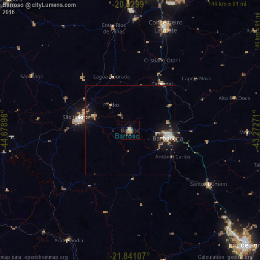
Analysis of Barroso night lights 2016
Square area 10x10 km:
 0.4%
0.4%90-99
1.19%80-89
1.59%70-79
1.98%60-69
3.57%50-59
0.79%40-49
1.19%30-39
1.98%20-29
1.59%10-19
0.79%0-9
84.92%Square area 50x50 km:
0.46%90-99
0.54%80-89
0.34%70-79
0.63%60-69
1.09%50-59
0.44%40-49
0.61%30-39
0.66%20-29
1.12%10-19
3.37%0-9
90.73%Clear (daylight) street map image can be seen on geolist.org.
Map coordinates:
20° 31' 47.6" South, 44° 40' 44.3" West
21° 11' 13" South, 43° 58' 33" West
21° 50' 27.9" South, 43° 16' 21.8" West
Some cities around Barroso sort by population:
• Barbacena
21.4 km =13.3 mi,  101°
101°
• Conselheiro Lafaiete
61.8 km =38.4 mi,  18°
18°
• São João del Rei
30.2 km =18.8 mi,  280°
280°
• Congonhas
76.8 km =47.7 mi,  9°
9°
• Santos Dumont
53.1 km =33 mi,  124°
124°
• Carandaí
31.3 km =19.4 mi,  34°
34°
• Lima Duarte
75.3 km =46.8 mi,  165°
165°
• Andrelândia
70.5 km =43.8 mi,  209°
209°
3470369 (p: 16,975)
Sources (retrieved 2019-11-25):
» Earth at Night: Flat Maps 2012, 2016