Lima Duarte night lights from space
Night Light of Lima Duarte (Minas Gerais) from space (Brazil) Src. Average luminocity for 10x10km area is 4.1071% and for 50x50km: 0.3451%.
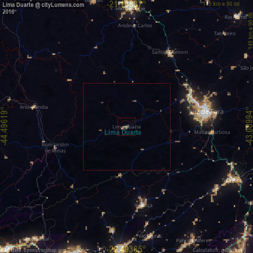
Analysis of Lima Duarte night lights 2016
Square area 10x10 km:
 0%
0%90-99
0%80-89
0%70-79
0.79%60-69
1.59%50-59
0.79%40-49
2.38%30-39
0.6%20-29
0.99%10-19
0.6%0-9
92.26%Square area 50x50 km:
0%90-99
0%80-89
0%70-79
0.03%60-69
0.12%50-59
0.13%40-49
0.2%30-39
0.06%20-29
0.1%10-19
0.06%0-9
99.3%Clear (daylight) street map image can be seen on geolist.org.
Map coordinates:
21° 11' 18.1" South, 44° 29' 46.3" West
21° 50' 33" South, 43° 47' 35" West
22° 29' 37.1" South, 43° 5' 23.8" West
Some cities around Lima Duarte sort by population:
• Juiz de Fora
46.5 km =28.9 mi,  79°
79°
• Três Rios
67.5 km =41.9 mi,  116°
116°
• Valença
45.8 km =28.5 mi,  167°
167°
• Santos Dumont
49.6 km =30.8 mi,  30°
30°
• Paraíba do Sul
62.4 km =38.8 mi, 124°
• Vassouras
63.9 km =39.7 mi, 167°
• Matias Barbosa
49 km =30.4 mi,  93°
93°
• Andrelândia
54.5 km =33.9 mi,  282°
282°
3458591 (p: 13,480)
Sources (retrieved 2019-11-25):
» Earth at Night: Flat Maps 2012, 2016