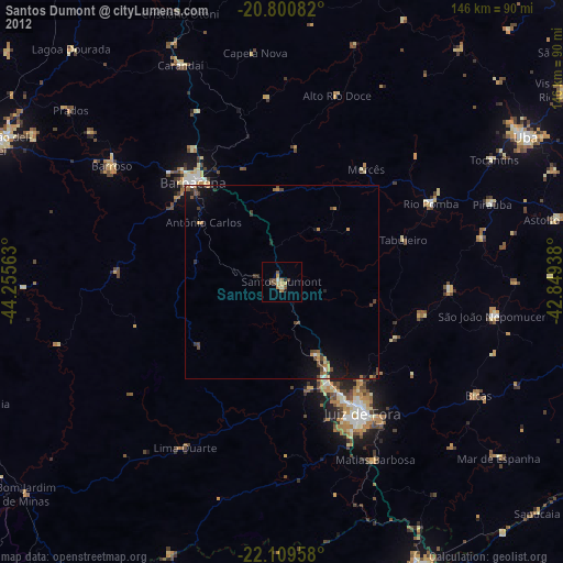
Santos Dumont night lights from space
Night Light of Santos Dumont (Minas Gerais) from space (Brazil) Src. Average luminocity for 10x10km area is 12.858% and for 50x50km: 2.9808%.
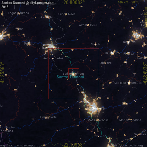
Analysis of Santos Dumont night lights 2016
Square area 10x10 km:
 0.57%
0.57%90-99
0.38%80-89
1.52%70-79
3.03%60-69
3.98%50-59
1.89%40-49
2.08%30-39
1.89%20-29
1.89%10-19
1.52%0-9
81.25%Square area 50x50 km:
0.15%90-99
0.17%80-89
0.14%70-79
0.45%60-69
0.86%50-59
0.37%40-49
0.54%30-39
0.61%20-29
0.77%10-19
2.7%0-9
93.24%Clear (daylight) street map image can be seen on geolist.org.
Map coordinates:
20° 48' 3" South, 44° 15' 20.3" West
21° 27' 24" South, 43° 33' 9" West
22° 6' 34.5" South, 42° 50' 57.8" West
Some cities around Santos Dumont sort by population:
• Juiz de Fora
40.1 km =24.9 mi,  148°
148°
• Barbacena
34.4 km =21.4 mi,  318°
318°
• São João Nepomuceno
56.8 km =35.3 mi,  99°
99°
• Barroso
53.1 km =33 mi,  304°
304°
• Rio Pomba
43.6 km =27.1 mi,  62°
62°
• Lima Duarte
49.6 km =30.8 mi,  210°
210°
• Matias Barbosa
51.8 km =32.2 mi, 152°
• Rio Novo
44.2 km =27.5 mi,  92°
92°
3449427 (p: 41,582)
Sources (retrieved 2019-11-25):
» Earth at Night: Flat Maps 2012, 2016