Barra Velha night lights from space
Night Light of Barra Velha (Santa Catarina) from space (Brazil) Src. Average luminocity for 10x10km area is 24.8087% and for 50x50km: 8.5557%.
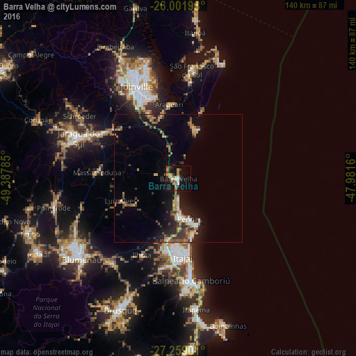
Analysis of Barra Velha night lights 2016
Square area 10x10 km:
 2.65%
2.65%90-99
2.65%80-89
3.41%70-79
4.55%60-69
3.41%50-59
3.03%40-49
2.65%30-39
5.11%20-29
1.33%10-19
31.25%0-9
39.96%Square area 50x50 km:
0.75%90-99
0.8%80-89
0.9%70-79
1.27%60-69
1.51%50-59
1.27%40-49
1.11%30-39
1.7%20-29
2.33%10-19
6.81%0-9
81.56%Clear (daylight) street map image can be seen on geolist.org.
Map coordinates:
26° 0' 7.1" South, 49° 23' 16.3" West
26° 37' 56" South, 48° 41' 5" West
27° 15' 32.4" South, 47° 58' 53.8" West
Some cities around Barra Velha sort by population:
• Joinville
39.8 km =24.7 mi,  336°
336°
• Itajaí
30.7 km =19.1 mi,  175°
175°
• Jaraguá do Sul
41.3 km =25.7 mi,  293°
293°
• Balneário Camboriú
40.2 km =25 mi,  172°
172°
• Navegantes
29.8 km =18.5 mi, 174°
• Gaspar
43 km =26.7 mi,  219°
219°
• Guaramirim
36.2 km =22.5 mi,  299°
299°
• Penha
15.7 km =9.8 mi, 165°
3470597 (p: 17,665)
Sources (retrieved 2019-11-25):
» Earth at Night: Flat Maps 2012, 2016