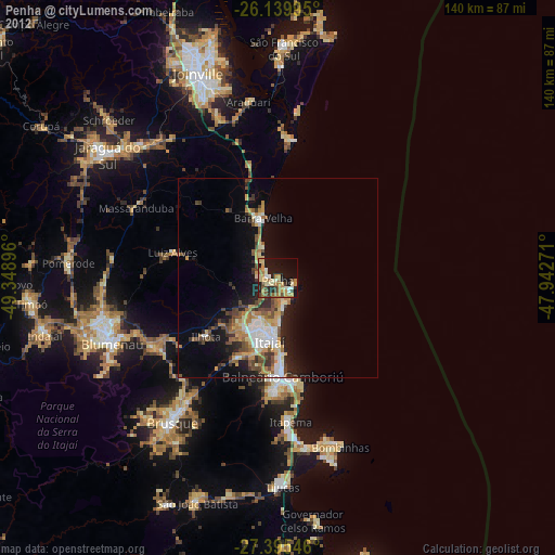
Penha night lights from space
Night Light of Penha (Santa Catarina) from space (Brazil) Src. Average luminocity for 10x10km area is 48.2917% and for 50x50km: 13.6866%.

Analysis of Penha night lights 2016
Square area 10x10 km:
 10.52%
90-99
12.1%80-89
5.56%70-79
6.15%60-69
3.77%50-59
3.97%40-49
4.37%30-39
7.74%20-29
19.25%10-19
18.65%0-9
7.94%Square area 50x50 km:
2.28%90-99
2.25%80-89
1.3%70-79
1.65%60-69
1.78%50-59
2.28%40-49
1.82%30-39
2.44%20-29
3.81%10-19
8.1%0-9
72.31%Clear (daylight) street map image can be seen on geolist.org.
Map coordinates:
26° 8' 23.8" South, 49° 20' 56.3" West
26° 46' 10" South, 48° 38' 45" West
27° 23' 43.7" South, 47° 56' 33.8" West
Some cities around Penha sort by population:
• Blumenau
44.9 km =27.9 mi,  248°
248°
• Itajaí
15.5 km =9.6 mi,  185°
185°
• Balneário Camboriú
24.6 km =15.3 mi,  177°
177°
• Navegantes
14.4 km =8.9 mi, 183°
• Itapema
35.8 km =22.2 mi,  174°
174°
• Gaspar
35.9 km =22.3 mi,  239°
239°
• Barra Velha
15.7 km =9.8 mi,  345°
345°
• Porto Belo
44.1 km =27.4 mi, 167°
3454213 (p: 20,096)
Sources (retrieved 2019-11-25):
» Earth at Night: Flat Maps 2012, 2016