Walcourt night lights from space
Night Light of Walcourt (Wallonia) from space (Belgium) Src. Average luminocity for 10x10km area is 8.0508% and for 50x50km: 16.6255%.
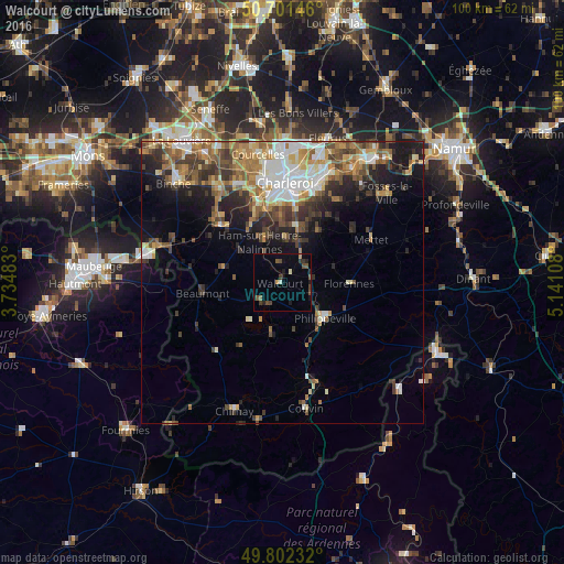
Analysis of Walcourt night lights 2016
Square area 10x10 km:
 0%
0%90-99
0.94%80-89
0.13%70-79
1.07%60-69
0.13%50-59
2.27%40-49
2.67%30-39
1.87%20-29
1.74%10-19
2.41%0-9
86.76%Square area 50x50 km:
2.48%90-99
2.97%80-89
1.88%70-79
2.27%60-69
2.61%50-59
2.52%40-49
2.94%30-39
2.89%20-29
3.64%10-19
6.14%0-9
69.66%Clear (daylight) street map image can be seen on geolist.org.
Map coordinates:
50° 42' 5.3" North, 3° 44' 5.4" East
50° 15' 14.4" North, 4° 26' 16.7" East
49° 48' 8.4" North, 5° 8' 27.9" East
Some cities around Walcourt sort by population:
• Charleroi
17.5 km =10.9 mi,  1°
1°
• Thuin
14.4 km =8.9 mi,  311°
311°
• Mettet
17.6 km =10.9 mi,  64°
64°
• Gerpinnes
11.3 km =7 mi,  34°
34°
• Florennes
12 km =7.5 mi,  91°
91°
• Philippeville
9.9 km =6.2 mi,  130°
130°
• Beaumont
14.3 km =8.9 mi,  262°
262°
• Lobbes
16.3 km =10.1 mi, 312°
2784189 (p: 17,501)
Sources (retrieved 2019-11-25):
» Earth at Night: Flat Maps 2012, 2016