Florennes night lights from space
Night Light of Florennes (Wallonia) from space (Belgium) Src. Average luminocity for 10x10km area is 2.4947% and for 50x50km: 16.9819%.
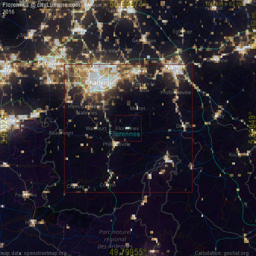
Analysis of Florennes night lights 2016
Square area 10x10 km:
 0%
0%90-99
0.53%80-89
0.53%70-79
0%60-69
0%50-59
0%40-49
1.07%30-39
0%20-29
0.53%10-19
0%0-9
97.33%Square area 50x50 km:
2.64%90-99
3.28%80-89
1.88%70-79
2.2%60-69
2.64%50-59
2.36%40-49
2.81%30-39
2.53%20-29
3.89%10-19
6.22%0-9
69.54%Clear (daylight) street map image can be seen on geolist.org.
Map coordinates:
50° 41' 55.5" North, 3° 54' 11.7" East
50° 15' 4.6" North, 4° 36' 22.9" East
49° 47' 58.4" North, 5° 18' 34.2" East
Some cities around Florennes sort by population:
• Châtelet
17.8 km =11.1 mi,  341°
341°
• Walcourt
12 km =7.5 mi,  271°
271°
• Mettet
8.7 km =5.4 mi,  27°
27°
• Gerpinnes
11.1 km =6.9 mi,  329°
329°
• Fosses-la-Ville
17.2 km =10.7 mi,  21°
21°
• La Bruyère
16 km =9.9 mi,  2°
2°
• Philippeville
7.6 km =4.7 mi,  215°
215°
• Hastière-Lavaux
15.9 km =9.9 mi,  103°
103°
2798276 (p: 10,723)
Sources (retrieved 2019-11-25):
» Earth at Night: Flat Maps 2012, 2016