Thuin night lights from space
Night Light of Thuin (Wallonia) from space (Belgium) Src. Average luminocity for 10x10km area is 16.549% and for 50x50km: 25.6483%.
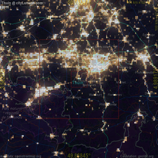
Analysis of Thuin night lights 2016
Square area 10x10 km:
 0.28%
0.28%90-99
0.28%80-89
1.26%70-79
1.12%60-69
4.2%50-59
1.4%40-49
4.06%30-39
2.1%20-29
11.2%10-19
24.93%0-9
49.16%Square area 50x50 km:
3.79%90-99
4.47%80-89
2.53%70-79
3.13%60-69
3.96%50-59
3.96%40-49
4.47%30-39
4.61%20-29
7.98%10-19
13.19%0-9
47.91%Clear (daylight) street map image can be seen on geolist.org.
Map coordinates:
50° 47' 9.5" North, 3° 34' 58.5" East
50° 20' 21.6" North, 4° 17' 9.7" East
49° 53' 18.4" North, 4° 59' 21" East
Some cities around Thuin sort by population:
• Charleroi
13.8 km =8.6 mi,  54°
54°
• Binche
11.8 km =7.3 mi,  313°
313°
• Morlanwelz-Mariemont
13.2 km =8.2 mi,  347°
347°
• Anderlues
7.6 km =4.7 mi, 352°
• Jeumont, FR
14 km =8.7 mi,  250°
250°
• Erquelinnes
12.9 km =8 mi, 253°
• Beaumont
11.9 km =7.4 mi,  196°
196°
• Lobbes
2 km =1.2 mi,  317°
317°
2785517 (p: 14,682)
Sources (retrieved 2019-11-25):
» Earth at Night: Flat Maps 2012, 2016