Philippeville night lights from space
Night Light of Philippeville (Wallonia) from space (Belgium) Src. Average luminocity for 10x10km area is 8.4171% and for 50x50km: 9.6661%.
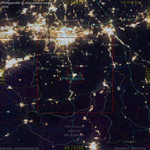
Analysis of Philippeville night lights 2016
Square area 10x10 km:
 0.8%
0.8%90-99
1.34%80-89
0.53%70-79
1.07%60-69
0.8%50-59
1.07%40-49
2.94%30-39
0.53%20-29
0.53%10-19
1.07%0-9
89.3%Square area 50x50 km:
1.23%90-99
1.38%80-89
0.92%70-79
1.12%60-69
1.26%50-59
1.36%40-49
1.96%30-39
1.89%20-29
3%10-19
4.89%0-9
80.99%Clear (daylight) street map image can be seen on geolist.org.
Map coordinates:
50° 38' 38.8" North, 3° 50' 26.2" East
50° 11' 46" North, 4° 32' 37.5" East
49° 44' 38" North, 5° 14' 48.7" East
Some cities around Philippeville sort by population:
• Walcourt
9.9 km =6.2 mi,  310°
310°
• Couvin
16.3 km =10.1 mi,  192°
192°
• Mettet
16.3 km =10.1 mi,  31°
31°
• Gerpinnes
15.8 km =9.8 mi,  355°
355°
• Florennes
7.6 km =4.7 mi,  35°
35°
• Givet, FR
21.1 km =13.1 mi,  107°
107°
• Beaumont
22.1 km =13.7 mi,  281°
281°
• Hastière-Lavaux
20.1 km =12.5 mi,  82°
82°
2789016 (p: 8,051)
Sources (retrieved 2019-11-25):
» Earth at Night: Flat Maps 2012, 2016