Soumagne night lights from space
Night Light of Soumagne (Wallonia) from space (Belgium) Src. Average luminocity for 10x10km area is 33.8422% and for 50x50km: 22.9751%.
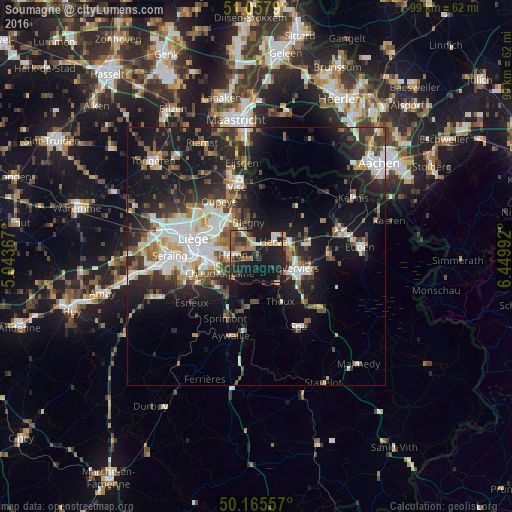
Analysis of Soumagne night lights 2016
Square area 10x10 km:
 4.14%
4.14%90-99
3.48%80-89
4.28%70-79
2.94%60-69
6.68%50-59
5.08%40-49
4.81%30-39
5.88%20-29
12.17%10-19
40.78%0-9
9.76%Square area 50x50 km:
4.09%90-99
4.71%80-89
1.79%70-79
1.84%60-69
2.76%50-59
3.24%40-49
3.15%30-39
3.84%20-29
7.4%10-19
17.21%0-9
49.97%Clear (daylight) street map image can be seen on geolist.org.
Map coordinates:
51° 3' 28.4" North, 5° 2' 37.2" East
50° 36' 49.9" North, 5° 44' 48.4" East
50° 9' 56.1" North, 6° 26' 59.7" East
Some cities around Soumagne sort by population:
• Verviers
8.6 km =5.3 mi,  108°
108°
• Herve
4.5 km =2.8 mi,  47°
47°
• Fléron
4.7 km =2.9 mi,  271°
271°
• Dison
7.5 km =4.7 mi,  93°
93°
• Blégny
6.7 km =4.2 mi,  346°
346°
• Beyne-Heusay
5.8 km =3.6 mi,  279°
279°
• Pepinster
6.1 km =3.8 mi,  137°
137°
• Trooz
6.1 km =3.8 mi,  216°
216°
2786344 (p: 15,237)
Sources (retrieved 2019-11-25):
» Earth at Night: Flat Maps 2012, 2016