Trooz night lights from space
Night Light of Trooz (Wallonia) from space (Belgium) Src. Average luminocity for 10x10km area is 26.639% and for 50x50km: 21.0808%.
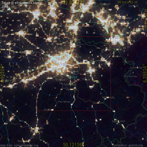
Analysis of Trooz night lights 2016
Square area 10x10 km:
 2.14%
2.14%90-99
2.67%80-89
2.54%70-79
0.94%60-69
3.74%50-59
6.02%40-49
7.22%30-39
6.95%20-29
10.7%10-19
29.01%0-9
28.07%Square area 50x50 km:
3.81%90-99
4.43%80-89
1.67%70-79
1.75%60-69
2.49%50-59
2.88%40-49
2.88%30-39
3.3%20-29
6.37%10-19
15.33%0-9
55.08%Clear (daylight) street map image can be seen on geolist.org.
Map coordinates:
51° 0' 53" North, 4° 59' 31.5" East
50° 34' 12.9" North, 5° 41' 42.8" East
50° 7' 17.6" North, 6° 23' 54" East
Some cities around Trooz sort by population:
• Chaudfontaine
4.5 km =2.8 mi,  287°
287°
• Fléron
5.1 km =3.2 mi,  348°
348°
• Soumagne
6.1 km =3.8 mi,  36°
36°
• Esneux
9.8 km =6.1 mi,  247°
247°
• Sprimont
7.2 km =4.5 mi,  200°
200°
• Beyne-Heusay
6.2 km =3.9 mi,  339°
339°
• Theux
9.2 km =5.7 mi,  116°
116°
• Pepinster
7.8 km =4.8 mi,  87°
87°
2785208 (p: 7,559)
Sources (retrieved 2019-11-25):
» Earth at Night: Flat Maps 2012, 2016