Pepinster night lights from space
Night Light of Pepinster (Wallonia) from space (Belgium) Src. Average luminocity for 10x10km area is 26.4198% and for 50x50km: 20.229%.
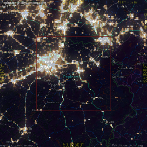
Analysis of Pepinster night lights 2016
Square area 10x10 km:
100  4.81%
4.81%
90-99 5.61%
80-89 1.07%
70-79 0.27%
60-69 3.21%
50-59 2.67%
40-49 4.28%
30-39 4.01%
20-29 9.76%
10-19 33.69%
0-9 30.61%
4.81%90-99
5.61%80-89
1.07%70-79
0.27%60-69
3.21%50-59
2.67%40-49
4.28%30-39
4.01%20-29
9.76%10-19
33.69%0-9
30.61%Square area 50x50 km:
100 4.14%
90-99 4.68%
80-89 1.56%
70-79 1.58%
60-69 2.27%
50-59 2.49%
40-49 2.6%
30-39 2.88%
20-29 5.74%
10-19 13.09%
0-9 58.96%
4.14%90-99
4.68%80-89
1.56%70-79
1.58%60-69
2.27%50-59
2.49%40-49
2.6%30-39
2.88%20-29
5.74%10-19
13.09%0-9
58.96%Clear (daylight) street map image can be seen on geolist.org.
Map coordinates:
51° 1' 5.4" North, 5° 6' 6.4" East
50° 34' 25.5" North, 5° 48' 17.6" East
50° 7' 30.3" North, 6° 30' 28.9" East
Some cities around Pepinster sort by population:
• Verviers
4.4 km =2.7 mi,  67°
67°
• Herve
7.5 km =4.7 mi,  353°
353°
• Fléron
9.9 km =6.2 mi,  297°
297°
• Soumagne
6.1 km =3.8 mi,  317°
317°
• Dison
5.3 km =3.3 mi,  40°
40°
• Theux
4.5 km =2.8 mi,  173°
173°
• Trooz
7.8 km =4.8 mi,  267°
267°
• Limbourg
10.5 km =6.5 mi, 66°
2789190 (p: 9,530)
Sources (retrieved 2019-11-25):
» Earth at Night: Flat Maps 2012, 2016