Fléron night lights from space
Night Light of Fléron (Wallonia) from space (Belgium) Src. Average luminocity for 10x10km area is 51.4826% and for 50x50km: 22.868%.
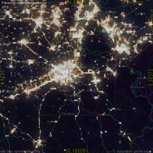
Analysis of Fléron night lights 2016
Square area 10x10 km:
100  9.09%
9.09%
90-99 9.22%
80-89 5.88%
70-79 4.14%
60-69 10.56%
50-59 12.83%
40-49 9.09%
30-39 6.55%
20-29 12.43%
10-19 15.64%
0-9 4.55%
9.09%90-99
9.22%80-89
5.88%70-79
4.14%60-69
10.56%50-59
12.83%40-49
9.09%30-39
6.55%20-29
12.43%10-19
15.64%0-9
4.55%Square area 50x50 km:
100 3.83%
90-99 4.5%
80-89 1.83%
70-79 1.86%
60-69 2.69%
50-59 3.29%
40-49 3.25%
30-39 3.73%
20-29 7.48%
10-19 18.33%
0-9 49.2%
3.83%90-99
4.5%80-89
1.83%70-79
1.86%60-69
2.69%50-59
3.29%40-49
3.25%30-39
3.73%20-29
7.48%10-19
18.33%0-9
49.2%Clear (daylight) street map image can be seen on geolist.org.
Map coordinates:
51° 3' 33.1" North, 4° 58' 39" East
50° 36' 54.6" North, 5° 40' 50.2" East
50° 10' 0.8" North, 6° 23' 1.5" East
Some cities around Fléron sort by population:
• Liège
8.2 km =5.1 mi,  284°
284°
• Herstal
6.8 km =4.2 mi,  323°
323°
• Chaudfontaine
4.9 km =3 mi,  222°
222°
• Herve
8.5 km =5.3 mi,  70°
70°
• Soumagne
4.7 km =2.9 mi,  91°
91°
• Blégny
7.1 km =4.4 mi,  26°
26°
• Beyne-Heusay
1.4 km =0.9 mi,  306°
306°
• Trooz
5.1 km =3.2 mi,  168°
168°
2798301 (p: 15,994)
Sources (retrieved 2019-11-25):
» Earth at Night: Flat Maps 2012, 2016