Herve night lights from space
Night Light of Herve (Wallonia) from space (Belgium) Src. Average luminocity for 10x10km area is 33.6404% and for 50x50km: 24.9097%.
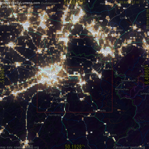
Analysis of Herve night lights 2016
Square area 10x10 km:
100  4.81%
4.81%
90-99 5.48%
80-89 4.14%
70-79 2.67%
60-69 5.88%
50-59 3.07%
40-49 2.41%
30-39 4.01%
20-29 11.76%
10-19 49.06%
0-9 6.68%
4.81%90-99
5.48%80-89
4.14%70-79
2.67%60-69
5.88%50-59
3.07%40-49
2.41%30-39
4.01%20-29
11.76%10-19
49.06%0-9
6.68%Square area 50x50 km:
100 4.67%
90-99 5.44%
80-89 2.05%
70-79 1.8%
60-69 2.91%
50-59 3.4%
40-49 3.31%
30-39 4.34%
20-29 7.77%
10-19 16.99%
0-9 47.33%
4.67%90-99
5.44%80-89
2.05%70-79
1.8%60-69
2.91%50-59
3.4%40-49
3.31%30-39
4.34%20-29
7.77%10-19
16.99%0-9
47.33%Clear (daylight) street map image can be seen on geolist.org.
Map coordinates:
51° 5' 4.6" North, 5° 5' 25.4" East
50° 38' 27" North, 5° 47' 36.7" East
50° 11' 34.1" North, 6° 29' 47.9" East
Some cities around Herve sort by population:
• Verviers
7.5 km =4.7 mi,  139°
139°
• Fléron
8.5 km =5.3 mi,  250°
250°
• Soumagne
4.5 km =2.8 mi,  227°
227°
• Dison
5.4 km =3.4 mi,  129°
129°
• Blégny
6 km =3.7 mi,  306°
306°
• Beyne-Heusay
9.3 km =5.8 mi,  257°
257°
• Pepinster
7.5 km =4.7 mi,  173°
173°
• Dalhem
9.3 km =5.8 mi,  330°
330°
2795912 (p: 16,544)
Sources (retrieved 2019-11-25):
» Earth at Night: Flat Maps 2012, 2016