Sombreffe night lights from space
Night Light of Sombreffe (Wallonia) from space (Belgium) Src. Average luminocity for 10x10km area is 16.3599% and for 50x50km: 31.4276%.
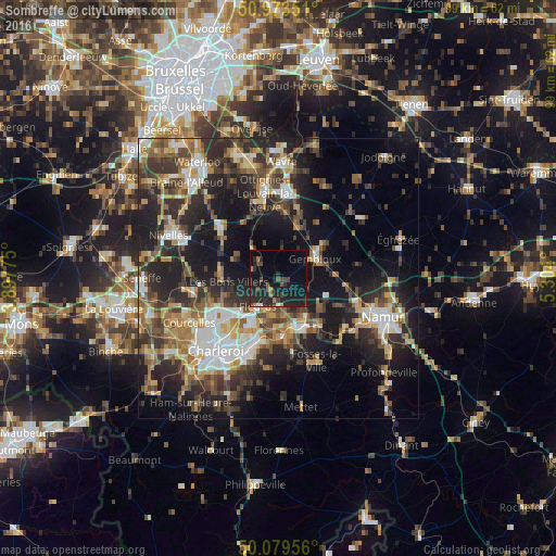
Analysis of Sombreffe night lights 2016
Square area 10x10 km:
 0.28%
0.28%90-99
0.56%80-89
0.14%70-79
0.14%60-69
3.08%50-59
1.68%40-49
4.76%30-39
2.38%20-29
14.57%10-19
25.21%0-9
47.2%Square area 50x50 km:
3.96%90-99
5.07%80-89
3.21%70-79
3.9%60-69
4.91%50-59
4.92%40-49
5.62%30-39
6.37%20-29
11.62%10-19
18.05%0-9
32.39%Clear (daylight) street map image can be seen on geolist.org.
Map coordinates:
50° 58' 24.6" North, 3° 53' 51.9" East
50° 31' 43.1" North, 4° 36' 3.1" East
50° 4' 46.4" North, 5° 18' 14.4" East
Some cities around Sombreffe sort by population:
• Fleurus
6.2 km =3.9 mi,  215°
215°
• Gembloux
7.8 km =4.8 mi,  62°
62°
• Farciennes
11.7 km =7.3 mi,  200°
200°
• Villers-la-Ville
7.3 km =4.5 mi,  305°
305°
• Court-Saint-Étienne
11.9 km =7.4 mi,  348°
348°
• Brunehault
12.2 km =7.6 mi,  257°
257°
• Mont-Saint-Guibert
11.8 km =7.3 mi,  3°
3°
• Chastre-Villeroux-Blanmont
9.3 km =5.8 mi,  18°
18°
2786390 (p: 7,452)
Sources (retrieved 2019-11-25):
» Earth at Night: Flat Maps 2012, 2016