Court-Saint-Étienne night lights from space
Night Light of Court-Saint-Étienne (Wallonia) from space (Belgium) Src. Average luminocity for 10x10km area is 32.7981% and for 50x50km: 38.7404%.
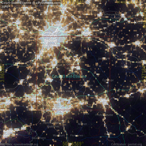
Analysis of Court-Saint-Étienne night lights 2016
Square area 10x10 km:
 5.88%
5.88%90-99
5.61%80-89
2.67%70-79
1.6%60-69
4.41%50-59
3.21%40-49
6.82%30-39
5.48%20-29
12.83%10-19
29.55%0-9
21.93%Square area 50x50 km:
7.52%90-99
6.55%80-89
3.51%70-79
4.67%60-69
5.85%50-59
6%40-49
6.01%30-39
7.15%20-29
11.61%10-19
18.45%0-9
22.7%Clear (daylight) street map image can be seen on geolist.org.
Map coordinates:
51° 4' 39.5" North, 3° 51' 55.4" East
50° 38' 1.6" North, 4° 34' 6.6" East
50° 11' 8.5" North, 5° 16' 17.9" East
Some cities around Court-Saint-Étienne sort by population:
• Louvain-la-Neuve
5 km =3.1 mi,  40°
40°
• Genappe
8.6 km =5.3 mi,  253°
253°
• Basse Lasne
8.7 km =5.4 mi,  321°
321°
• Villers-la-Ville
8.3 km =5.2 mi,  206°
206°
• Ottignies
3.5 km =2.2 mi,  358°
358°
• Mont-Saint-Guibert
3 km =1.9 mi,  88°
88°
• Chastre-Villeroux-Blanmont
5.9 km =3.7 mi,  118°
118°
• Walhain-Saint-Paul
9.2 km =5.7 mi,  95°
95°
2800042 (p: 9,353)
Sources (retrieved 2019-11-25):
» Earth at Night: Flat Maps 2012, 2016